
Stewards of the Visual Exposition


(1/28 AM Update) Winter Storm; Tonight & Sat


News Release:
Good Morning Everyone,
The latest update from the National Weather Service (NWS) can be found in the email below and attached briefing. Notable changes to the forecast for Beaufort County included:
Details of how these changes impacted the forecast for Beaufort County have been highlighted below.
Current Beaufort County Forecast
Precipitation
Light rain will begin to move into our area after 4pm today, and continue through 11pm . A transition to snow is expected after 11pm tonight for most areas of the Beaufort County, and continue through 11am Saturday morning. Snow accumulations will vary across Beaufort County as follows:
Rain and snow is expected to be somewhat scattered and light as bands move through Beaufort County.
Winds
North winds will begin to increase after sunrise Saturday becoming sustained between 10 and 20 mph, and continuing through the daylight hours. Frequent gust between 20 and 30 mph are expected during this time. North winds between 5 and 10 mph will continue through 4pm Sunday before transitioning to the south throughout the afternoon.
These winds along with below freezing temperatures will create windchills in the low twenties through sunset Saturday, and single digits through sunset Sunday.
Anticipated Hazards / Things To Prepare For
The NWS will be hosting a series of live webinars pertaining to this storm as follows:
You can register for all of the webinars using this same link.
Our next update is scheduled for 6pm today. We encourage everyone to continue to monitor local media outlets for more information.
As always, thank you all for what you do to keep Beaufort County informed, prepared and safe.
Chris Newkirk
Deputy Director, Beaufort County Emergency Services
1420 Highland Dr
Washington, NC 27889
Good Morning,
Only minor adjustments to the forecast snowfall amounts this morning. The Winter Storm Watches have been upgraded to Winter Weather Advisories, with additional Winter Weather Advisories for all counties along and north of Hwy 264. Minor to moderate impacts from snowfall expected in the advisory area, with hazardous travel being the primary concern. Additionally, Wind Advisories have been issued for the Outer Banks north of Ocracoke Inlet, with Gale Watches and Warnings for most area waters.
Very cold temperatures are still expected Saturday night/Sunday morning, resulting in a hard refreeze and continued hazardous travel conditions due to black ice.
Please join us as we discuss all this and more on our webinar briefing at 9 AM this morning. You can register for the webinar here.
Thank You,
NWS Morehead City
NOAA - National Weather Service
Newport/Morehead City, NC Weather Forecast Office
533 Roberts Rd
Newport, NC 28570
Go Back
Good Morning Everyone,
The latest update from the National Weather Service (NWS) can be found in the email below and attached briefing. Notable changes to the forecast for Beaufort County included:
- A northern shift in the snow line, resulting in changes to the anticipated snow accumulations for areas of Beaufort County.
Details of how these changes impacted the forecast for Beaufort County have been highlighted below.
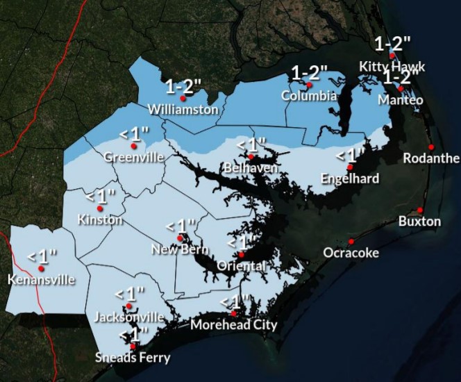
Current Beaufort County Forecast
Precipitation
Light rain will begin to move into our area after 4pm today, and continue through 11pm . A transition to snow is expected after 11pm tonight for most areas of the Beaufort County, and continue through 11am Saturday morning. Snow accumulations will vary across Beaufort County as follows:
- 1 to 2 inches for areas along and north of Old Ford, Pinetown, Pungo River and Ponzer.
- 3/4 to 1 inch for Chocowinity, Washington, Bath, Sidney, Pamlico Beach, Belhaven and Pantego.
- 1/2 to 3/4 of an inch for Blounts Creek, Edward and Aurora.
Rain and snow is expected to be somewhat scattered and light as bands move through Beaufort County.
Winds
North winds will begin to increase after sunrise Saturday becoming sustained between 10 and 20 mph, and continuing through the daylight hours. Frequent gust between 20 and 30 mph are expected during this time. North winds between 5 and 10 mph will continue through 4pm Sunday before transitioning to the south throughout the afternoon.
These winds along with below freezing temperatures will create windchills in the low twenties through sunset Saturday, and single digits through sunset Sunday.
Anticipated Hazards / Things To Prepare For
- Hazardous Road Conditions: We anticipate road conditions will begin to deteriorate after 11pm Friday night and remain hazardous through the weekend as temps are expected to remain at or below freezing through Monday. Any precipitation that remains on the roads Saturday and Sunday evenings is expected to refreeze quickly after sunset each day. We encourage everyone to avoid any unnecessary travel Friday night / Saturday morning, and drive with caution through the remainder of the weekend.
- Cold Temperatures: Again, temperatures are expected to be at or well below freezing Saturday and Sunday, with wind chills in the single digits to low teens. Please make the necessary arrangements to provide safety for outdoor pets / livestock, and protect any vulnerable infrastructure such as exposed water lines from freezing. We also encourage everyone to dress appropriately when going outdoors, and use caution when walking on frozen surfaces such as sidewalks, driveways, entry steps, etc.
The NWS will be hosting a series of live webinars pertaining to this storm as follows:
- Friday January 28th at 900 AM
You can register for all of the webinars using this same link.
Our next update is scheduled for 6pm today. We encourage everyone to continue to monitor local media outlets for more information.
As always, thank you all for what you do to keep Beaufort County informed, prepared and safe.
Chris Newkirk
Deputy Director, Beaufort County Emergency Services
1420 Highland Dr
Washington, NC 27889
Good Morning,
Only minor adjustments to the forecast snowfall amounts this morning. The Winter Storm Watches have been upgraded to Winter Weather Advisories, with additional Winter Weather Advisories for all counties along and north of Hwy 264. Minor to moderate impacts from snowfall expected in the advisory area, with hazardous travel being the primary concern. Additionally, Wind Advisories have been issued for the Outer Banks north of Ocracoke Inlet, with Gale Watches and Warnings for most area waters.
Very cold temperatures are still expected Saturday night/Sunday morning, resulting in a hard refreeze and continued hazardous travel conditions due to black ice.
Please join us as we discuss all this and more on our webinar briefing at 9 AM this morning. You can register for the webinar here.
Thank You,
NWS Morehead City
NOAA - National Weather Service
Newport/Morehead City, NC Weather Forecast Office
533 Roberts Rd
Newport, NC 28570

| 1/28/22 COVID Daily Surveillance Update | Local News & Expression, The Region | Supporting Student Veterans |


Home
Contact
About
Service Rates
Privacy Policy
Follow on Facebook
Subscribe to Newsletters
Rss Feed
Keywords
Eastern NC Now & ENC NOW © Copyright 1998-2024 All Rights Reserved.
