
Your Basic Needs: Food, Shelter and The TRUTH


AM Update (11/11/22) Tropical Depression Nicole


News Release:
Good Morning Everyone,
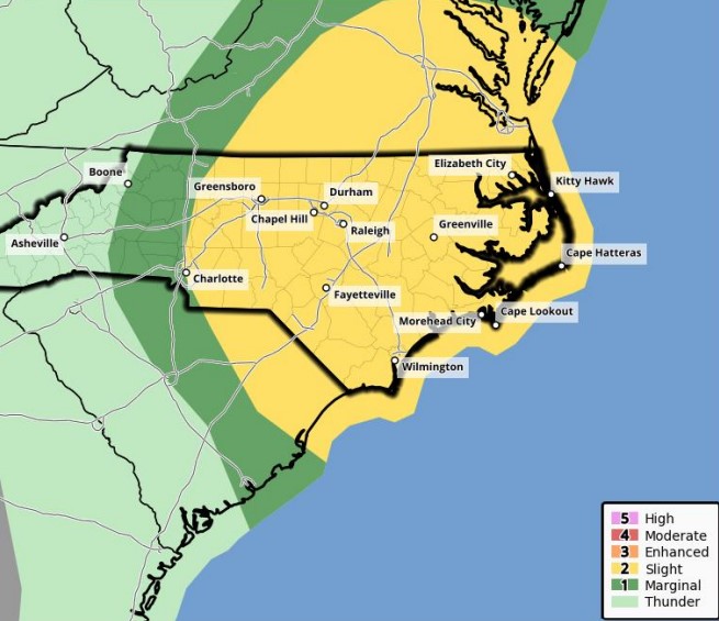
This morning's update from the National Weather Service included a Tornado Watch for Beaufort County, and made minor changes to the forecasted impacts for our area. These changes have been underlined below.
Rain
Winds
These transitioning winds will result in brief periods in which water is pushed in to and pulled out of susceptible waterways throughout our county.
Severe Thunderstorms / Tornado
Please see the email below and attached briefing from the National Weather Service for additional information. There will be no further updates related to TD Nicole.
We encourage everyone to ensure that you, your family, friends and neighbors have a way of receiving weather related watch and / or warning notifications. (Alert notifications on your cell phone and other smart devices, weather radios, etc.)
As always, thank you all for what you do to keep Beaufort County informed, prepared and safe.
Chris Newkirk
Deputy Director, Beaufort County Emergency Services
1420 Highland Dr
Washington, NC 27889
Office: (252)940-6511 • Cell: (252) 378-5352
**Tornado Watch in Effect for all of Eastern NC through 3 PM**
Good Morning Eastern NC Partners,
Nicole has weakened further to a Tropical Depression as the center of circulation moves northeastward through Georgia. Impacts from the remnant storm are still expected however. The main threat will be the possibility for a few tornadoes today, and a Tornado Watch is in effect for all of Eastern NC through 3PM this afternoon. There may be a break in the showers and storms by late afternoon through early evening, but additional showers with some embedded thunder are possible later this evening before it all moves off the coast late tonight. Activity this evening is not expected to be severe, though some periods of gusty winds in heavier showers are still possible.
As south winds increase late in the day today, and peak tonight, minor water level rises are possible on the soundside of Hatteras Island north of Buxton to Duck, as well as for Mainland Dare County. A Coastal Flood Advisory remains in effect for these locations from tonight through Saturday afternoon.
See the attached 2-page briefing for details on the tornado and coastal flood threat.
If you have any questions, please contact us at (252) 223-5737 Ext. 6.
Regards,
NWS Newport/Morehead City
NOAA - National Weather Service
Newport/Morehead City, NC Weather Forecast Office
533 Roberts Rd
Newport, NC 28570
Go Back
Good Morning Everyone,
This morning's update from the National Weather Service included a Tornado Watch for Beaufort County, and made minor changes to the forecasted impacts for our area. These changes have been underlined below.
Rain
- Rain chances will continue through 4am Saturday, with most areas expected to receive another 1/4 to 1/2 inch of rain as bands continue to move through Eastern NC.
- Our greatest chance of rain is currently forecasted to occur between 10am and 3pm today, with our heaviest rains expected between noon and 2pm.
Winds
- Sustained winds between 10 and 15 mph are expected through 4am Saturday morning, with frequent gust of 25 to 35 mph likely during this time.
- Our highest winds are forecasted to occur between 1pm today and 2am Saturday.
- These winds will transition as follows:
- SE winds between 8am and 7pm Friday.
- South winds between 7pm Friday and 4am Saturday.
- SW winds between 4am Saturday and 2am Sunday.
- West / NW winds after 2am Sunday.
These transitioning winds will result in brief periods in which water is pushed in to and pulled out of susceptible waterways throughout our county.
Severe Thunderstorms / Tornado
- Strong to severe thunderstorms, as well as isolated tornados are possible through 7pm today.
- A Tornado Watch has been issued for Beaufort County until 3pm.
Please see the email below and attached briefing from the National Weather Service for additional information. There will be no further updates related to TD Nicole.
We encourage everyone to ensure that you, your family, friends and neighbors have a way of receiving weather related watch and / or warning notifications. (Alert notifications on your cell phone and other smart devices, weather radios, etc.)
As always, thank you all for what you do to keep Beaufort County informed, prepared and safe.
Chris Newkirk
Deputy Director, Beaufort County Emergency Services
1420 Highland Dr
Washington, NC 27889
Office: (252)940-6511 • Cell: (252) 378-5352
**Tornado Watch in Effect for all of Eastern NC through 3 PM**
Good Morning Eastern NC Partners,
Nicole has weakened further to a Tropical Depression as the center of circulation moves northeastward through Georgia. Impacts from the remnant storm are still expected however. The main threat will be the possibility for a few tornadoes today, and a Tornado Watch is in effect for all of Eastern NC through 3PM this afternoon. There may be a break in the showers and storms by late afternoon through early evening, but additional showers with some embedded thunder are possible later this evening before it all moves off the coast late tonight. Activity this evening is not expected to be severe, though some periods of gusty winds in heavier showers are still possible.
As south winds increase late in the day today, and peak tonight, minor water level rises are possible on the soundside of Hatteras Island north of Buxton to Duck, as well as for Mainland Dare County. A Coastal Flood Advisory remains in effect for these locations from tonight through Saturday afternoon.
See the attached 2-page briefing for details on the tornado and coastal flood threat.
If you have any questions, please contact us at (252) 223-5737 Ext. 6.
Regards,
NWS Newport/Morehead City
NOAA - National Weather Service
Newport/Morehead City, NC Weather Forecast Office
533 Roberts Rd
Newport, NC 28570

| AM Update (11/10/22) - Tropical Storm Nicole | Local News & Expression, The Region | North Carolina Food Innovation Lab growing food business in North Carolina |

Latest The Region
 |
Our office is currently monitoring an approaching weather system that will bring windy conditions, rain, and the potential for strong storms to our area tomorrow.
Published: Thursday, April 11th, 2024 @ 2:53 pm
By: Eastern NC NOW Staff
|
 |
The great misnomer for non Christians that the day Jesus Christ was executed by occupying Romans, celebrated by Christians as "Good" Friday, must be a paradox of ominous proportions.
Published: Saturday, March 30th, 2024 @ 7:52 pm
By: Stan Deatherage
|
 |
Republicans Bokhari and Driggs retain seats on city council.
Published: Tuesday, March 26th, 2024 @ 12:50 am
By: Carolina Journal
|
 |
Recently, Golden LEAF President, Chief Executive Officer Scott T. Hamilton sat down with Don Flow, Immediate Past Chair of the Golden LEAF Foundation Board of Directors via Zoom and filmed an episode of Critical Conversations.
Published: Monday, March 25th, 2024 @ 1:14 am
By: Eastern NC NOW Staff
|
 |
At the December Board meeting, the Golden LEAF Board of Directors awarded $5,540,432 in funding for 50 projects through the Food Distribution Assistance Program.
Published: Friday, March 1st, 2024 @ 11:31 pm
By: Eastern NC NOW Staff
|
 |
At the December Board meeting, the Golden LEAF Board of Directors awarded $650,000 to support two projects through the Open Grants Program and $3,080,000 to support five projects through the SITE Program.
Published: Wednesday, February 28th, 2024 @ 12:20 pm
By: Eastern NC NOW Staff
|
 |
Members of the North Carolina Rural Health Association (NCRHA) visited Washington, D.C., on Feb. 14, 2024, to meet with elected officials and advocate for policies to improve access to care in rural areas.
Published: Wednesday, February 28th, 2024 @ 12:51 am
By: Eastern NC NOW Staff
|
 |
Today, the Golden LEAF Board of Directors awarded $650,000 to support two projects through the Open Grants Program and $3,080,000 to support five projects through the SITE Program.
Published: Monday, February 26th, 2024 @ 10:04 am
By: Eastern NC NOW Staff
|
 |
WASHINGTON, N.C. –– The Cherry Run Solid Waste Collection Site, located at 2860 Cherry Run Road, Washington, NC 27889, will temporarily close for repairs on Monday, Nov. 20
Published: Saturday, February 24th, 2024 @ 11:32 am
By: Eastern NC NOW Staff
|


Home
Contact
About
Service Rates
Privacy Policy
Follow on Facebook
Subscribe to Newsletters
Rss Feed
Keywords
Eastern NC Now & ENC NOW © Copyright 1998-2024 All Rights Reserved.
