News Release:
Good Afternoon Everyone,
The latest update from the National Weather Service (NWS) can be found in the email below and attached briefing. Notable changes to the forecast for Beaufort County included:
- A northern shift in the snow line, resulting in changes to the anticipated snow accumulations for areas of Beaufort County.
Details of how these changes impacted the forecast for Beaufort County are below.
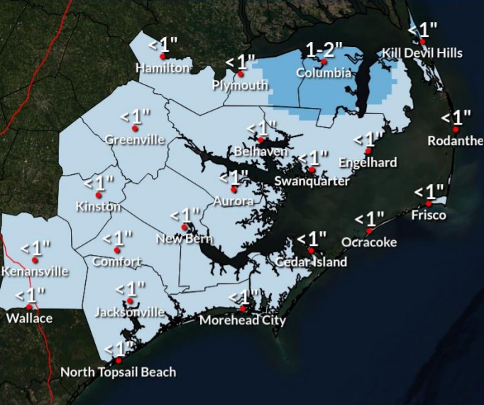
Current Beaufort County Forecast
 Precipitation
Scattered light rain is likely after 6pm, and expected to continue through 10pm, transitioning to periods of mixed rain and snow between 10 pm tonight and 1am Saturday morning. Light snow is expected from 1am to 11am tomorrow morning for most areas of the Beaufort County, with our heaviest snow, and most of our accumulation occurring between sunrise Saturday and 11am. All of Beaufort County is now forecasted to receive less than 1 inch of snow, with the northeast corner of our county receiving the most. Snow accumulations are still expected to vary as follows:
- 3/4 to 1 inch for areas along and north of Belhaven, Pantego and Long Acre.
- 1/2 to 3/4 of an inch for Washington, Bath, Sidney and Pamlico Beach.
- 1/2 an inch or less for Chocowinity, Blounts Creek, Edward and Aurora.
Rain and snow is still expected to be somewhat scattered and light as bands move through Beaufort County tonight.
Winds
North winds will begin to increase after sunrise Saturday becoming sustained between 10 and 20 mph, and continuing through the daylight hours. Frequent gust between 20 and 30 mph are expected during this time. North winds between 5 and 10 mph will continue through 7am Sunday before transitioning to the south by noon.
These winds along with below freezing temperatures will create windchills in the low twenties Saturday, and single digits near surise Sunday.
Anticipated Hazards / Things To Prepare For
- Hazardous Road Conditions: We anticipate road conditions will begin to deteriorate after 11pm Friday night and remain hazardous through the weekend as temps are expected to remain at or below freezing through Monday. Any precipitation that remains on the roads Saturday and Sunday evenings is expected to refreeze quickly after sunset each day. We encourage everyone to avoid any unnecessary travel Friday night / Saturday morning, and drive with caution through the remainder of the weekend.
- Cold Temperatures: Again, temperatures are expected to be at or well below freezing Saturday and Sunday, with wind chills ranging between single digits to the low twenties. Please make the necessary arrangements to provide safety for outdoor pets / livestock, and protect any vulnerable infrastructure such as exposed water lines from freezing. We also encourage everyone to dress appropriately when going outdoors, and use caution when walking on frozen surfaces such as sidewalks, driveways, entry steps, etc.
This is our final briefing for this storm system. We encourage everyone to continue to monitor local media outlets for more information.
As always, thank you all for what you do to keep Beaufort County informed, prepared and safe.
Chris Newkirk
Deputy Director, Beaufort County Emergency Services
1420 Highland Dr
Washington, NC 27889
Good afternoon,
Only minor adjustments to the forecast snowfall amounts this afternoon. Winter Weather Advisories continue for Eastern NC counties along and north of HWY 264. Minor to moderate impacts from snowfall expected in the advisory area, with hazardous travel being the primary concern. Additionally, Wind Advisories remain for the Outer Banks north of Ocracoke Inlet, with Gale Warnings for the coastal waters and sounds.
A Coastal Flood Advisory has been issued for minor water level rises from Rodanthe to Downeast Carteret county where inundation of 1 to 2 feet above ground will be possible for low-lying soundside areas adjacent to the Pamlico Sound.
Very cold temperatures are still expected Saturday night/Sunday morning, resulting in a hard refreeze and continued hazardous travel conditions due to black ice.
Thank You,
NWS Morehead City
NOAA - National Weather Service
Newport/Morehead City, NC Weather Forecast Office
533 Roberts Rd
Newport, NC 28570


