Good Afternoon Everyone,
This morning's update continued to shift the bulk of the forecasted precipitation south and east of our area. Updated forecast details for Beaufort County have been
underlined below.
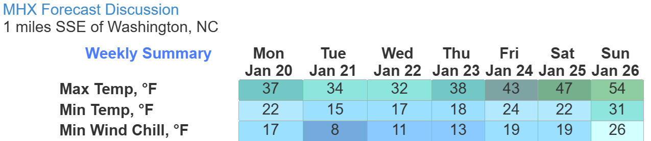
Cold Temperatures
- Below average temperatures and windchills are forecasted through Friday.
- Tuesday and Wednesday will be our coldest days, with daytime highs near freezing (windchills of 20 to 25) and nighttime lows between 15 and 20 degrees (windchills near 15).
Extended Forecast for Washington, NC
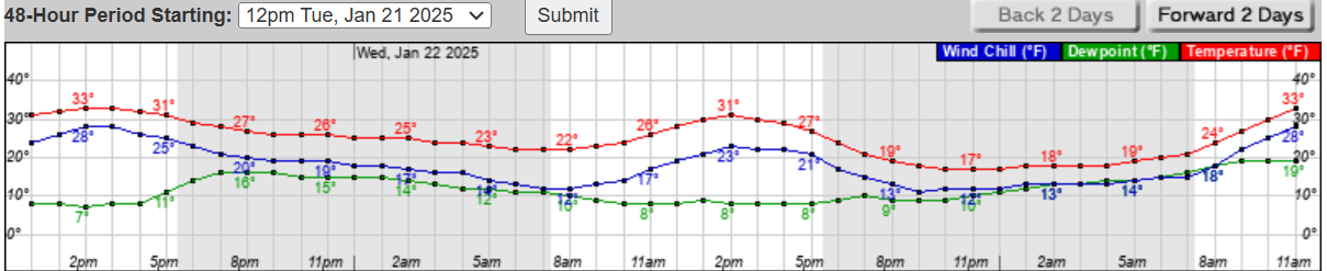
 Hourly Forecast for Tuesday & Wednesday
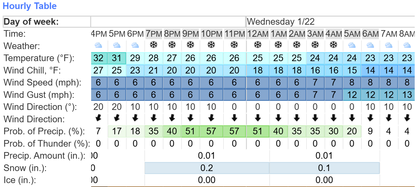
 Snow / Winter Precipitation
- Precipitation is expected to move into eastern NC around 8pm Tuesday night and continue through sunrise Wednesday, with most of our county receiving about an inch of snow.
- NOAA's Probabilistic Precipitation Portal can be viewed here https://www.wpc.ncep.noaa.gov/Prob_Precip/. This link will allow you to zoom in to local areas of Eastern NC. (Note: This link does not work well with phone or other devices with small screens.)
- An interactive NWS link with hourly forecast information can viewed here. https://www.weather.gov/forecastpoints
- Our greatest chance of snow is expected to occur between 10pm and midnight on Tuesday.
Tuesday Night / Wednesday Morning Hourly Forecast Graphic
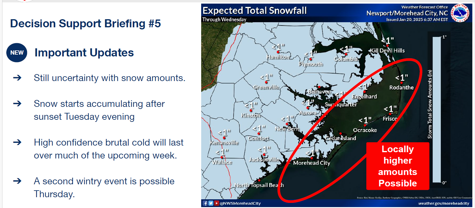
 NWS Snowfall Graphic
 Preparation Reminders
We encourage everyone to take the necessary precautions to safely protect you family, homes, and pets from these freezing temperature over the coming days. Recommended precautions include:
Preparation Reminders
We encourage everyone to take the necessary precautions to safely protect you family, homes, and pets from these freezing temperature over the coming days. Recommended precautions include:
- Utilize safe heating practices in your home. (Only use UL approved space heaters. Ensure heaters are at least 3 feet away from furniture and other combustible items. Make sure that you have working smoke alarms. Homes that utilize gas appliances should also have working carbon monoxide alarms as well.)
- Ensure exposed plumbing fixtures are wrapped to prevent freezing and familiarize yourselves with the location of your water shutoffs and / or water meter so that any leaks can quickly be shut off.
- Ensure that outside pets and livestock have adequate shelter to protect them from wind, rain, or frozen precipitation. Also ensure that they continue to have access to water that is not frozen.
Please see the email below and attached briefing from the National Weather Service (NWS) for more details. A recording of this morning's forecast briefing from the NWS can be viewed here. https://youtu.be/FA07yGa3Z78
We encourage everyone to continue to monitor this developing forecast and plan accordingly.
As always, thank you all for what you do to keep Beaufort County informed, prepared, and safe.
Chris Newkirk
Deputy Director
Beaufort County Emergency Services
1420 Highland Dr
Washington, NC 27889
Office: (252)940-6511
Cell: (252) 378-5352
Good morning,
Forecast confidence remains high that we will see some accumulating snow for portions of Eastern NC Tuesday evening into early Wednesday morning. Specific details like how much dry air will be in place to inhibit heavier snow totals and how strong the storm system gets are still uncertain. We still have quite a range in potential forecast outcomes. While we are forecasting a broad area of a trace to 1" for all of ENC, there are some forecast scenarios that indicate more snowfall on the coast, and less inland, so forecast uncertainty is higher than normal. A stronger storm closer to the coast means more snow, and a weaker system will mean less snow. The official forecast is SUBJECT TO CHANGE.
Also, extremely cold weather will impact our area through Thursday, where morning lows will be in the teens and wind chills in the single digits at times. Prolonged cold may cause issues with pipes and other sensitive infrastructure and if snow falls, it may linger for several days due to the extreme cold.
Thanks,
-NWS Morehead City
NWS_Morehead_City_Briefing_5_Winter_Weather_Jan_21_Jan_22_2025.pdf
Regards,
NWS Newport/Morehead City
NOAA - National Weather Service
Newport/Morehead City, NC Weather Forecast Office
533 Roberts Rd
Newport, NC 28570


