News Release:
Good Afternoon Everyone,
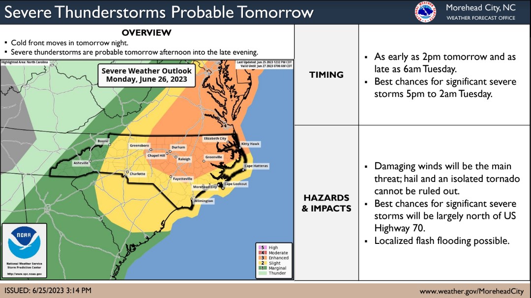
Our office is currently monitoring an increasing threat of severe weather tomorrow afternoon and night. There is a growing confidence that storms capable of producing damaging winds and hail will begin to develop along central and eastern NC between 5pm tomorrow afternoon and 2am Tuesday morning. Isolated tornados are also possible during this time. Forecast details for Beaufort County include:
Severe Storms
- Areas north and west of Blounts Creek, Bath and Pantego are at the greatest risk of receiving severe storms. These communities are currently included in an Enhanced Threat area (Level 3 of 5), meaning numerous persistent and widespread severe storms are possible. This is a classification that is not frequently used for our area. Previous forecasts with this designation were accompanied by storms that resulted in isolated structural damage and power outages. For example, the storms that produced last year's tornados in Aurora and Bay View were from a Enhanced threat forecast. *Note: The Enhanced Threat area has trended in a south east direction over the last 36 hrs. It would not be surprising to see more of our county included in the higher risk portion of the forecast with future updates.*
- Our greatest chance of experiencing severe storms is currently forecasted to occur between 9pm Monday and 1am Tuesday
- Damaging wind gust between 50 and 70mph will be the greatest threat associated with any storms that develop. Large hail and Isolated tornados can not be ruled out.

- Most areas of Beaufort County are currently forecasted to receive between 1/2 to 3/4 of an inch of rain. However, localized heavier amounts are possible depending on the track of any severe storms that pass through.
- Our greatest chance of rain is currently forecasted to occur between 9pm Monday and 2am Tuesday.
Winds
- SW winds are expected to be sustained between 10 and 20mph from 10am to midnight tomorrow. Frequent gust between 25 and 30 mph are expected from noon to midnight.
Please see the email below and attached briefing from the National Weather Service for more information. We anticipate another update tomorrow morning and will pass along information as we receive it. In the meantime, please take a moment to ensure that you, your family, friends and neighbors have a means of receiving weather notifications such as watches and warnings in advance of tomorrow's overnight threats.
As always, we thank you all for what you do to keep Beaufort County informed, prepared and safe.
Chris Newkirk
Director
Beaufort County Emergency Services
1420 Highland Dr
Washington, NC 27889
Office: (252)940-6511
Cell: (252) 378-5352
National Weather Service Email
Good afternoon,
The confidence in a severe weather threat for eastern North Carolina has increased since this morning.
What Has Changed: An Enhanced (Level 3/5) Risk has been introduced for the coastal plain and areas around the Albemarle Sound. All other areas remain in a Slight (Level 2/5) risk.
Primary Threats: Damaging winds are the main risk with these storms, along with the threat of hail. An isolated tornado is possible.
Timing: The highest severe risk runs from around 5 PM tomorrow to around 2 AM Tuesday. Storms could form as early as 2 PM and last through sunrise Tuesday, mainly along the coast.
The primary message has not changed - remain weather aware and have multiple ways to receive a warning.
If you have any questions, please don't hesitate to contact us.
Kind regards,
NWS Morehead City
--
NOAA - National Weather Service
Newport/Morehead City, NC Weather Forecast Office
533 Roberts Rd
Newport, NC 28570


