News Release:
Good Morning Everyone,
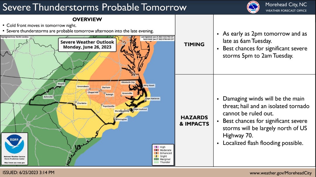
There were minor changes to this morning's update from the National Weather Service, which included a slightly later arrival of severe storms as well as an increasing concern for hail.
Beaufort County Forecast
Severe Storms
- Areas north and west of Blounts Creek, Bath, Pantego and Pungo River remain at an Enhanced Threat level, and are at the greatest risk of receiving severe storms. (An Enhanced Threat is a level 3 of 5 and means numerous persistent and widespread severe storms are possible.) Potential hazards from these storms include:
- Damaging wind gust between 50 and 70mph.
- Large hail (up to golf ball size)
- Isolated tornados
- Localized flash flooding.
- Our greatest chance of experiencing severe storms is currently forecasted to occur between 9pm Monday and 4am Tuesday. (This chance peaks at 11pm)
Rain
- Most areas of Beaufort County are currently forecasted to receive between 1/2 to 3/4 of an inch of rain. However, localized heavier amounts are possible depending on the track of any severe storms that pass through.
- Our greatest chance of rain is currently forecasted to occur between 9pm Monday and 3am Tuesday.
Winds
- SW winds are expected to be sustained between 10 and 20mph from 10am to midnight tomorrow. Frequent gust between 20 and 30 mph are expected from 2pm to midnight.
Please see the email below and attached briefing from the National Weather Service for more information.
We encourage everyone to ensure that you, your family, friends and neighbors have a means of receiving weather notifications such as watches and warnings in advance of tonight's threats. This could include weather radios, phone apps with push notifications, or any other device that is capable of waking you up and alerting you to approaching severe weather.
As always, we thank you all for what you do to keep Beaufort County informed, prepared and safe.
Chris Newkirk
Director
Beaufort County Emergency Services
1420 Highland Dr
Washington, NC 27889
Office: (252)940-6511
Cell: (252) 378-5352
National Weather Service Email
Good morning,
Attached is an updated briefing on the severe thunderstorm potential through tonight.
What Has Changed: The main change is a slightly later timing of the severe weather potential
Primary Threats: Damaging winds up to 70 mph are the main risk with these storms. Additional threats include large hail up to golf ball size, a tornado or two, and a few instances of flash flooding.
Timing: The highest severe weather risk is expected from around 5 pm this afternoon to 4 am, or later, early Tuesday morning.
The primary message has not changed - remain weather aware and have multiple ways to receive a warning. Of note, nighttime severe weather can be especially dangerous.
If you have any questions, please don't hesitate to contact us.
Please note that we are still experiencing intermittent issues with our public phone line and forecast tree. If you are trying to reach us, please use 252-223-2328. This will allow you to speak directly to a Meteorologist. Please note that this phone number is not a public line, so please do not disseminate this externally.
Kind regards,
NWS Morehead City
--
NOAA - National Weather Service
Newport/Morehead City, NC Weather Forecast Office
533 Roberts Rd
Newport, NC 28570


