Publisher's Note: This post appears here courtesy of the
John Locke Foundation. The author of this post is
Dr. Andy Jackson.
As part of the
North Carolina League of Conservation Voters v. Hall lawsuit, plaintiffs' attorneys put forward what they call
"optimized maps." They claim that those maps
"reduce the number of split municipalities" compared to maps enacted by the North Carolina General Assembly.
However, those
"optimized maps" take a meat cleaver to several North Carolina cities, cracking them across districts much deeper than is done in the enacted maps. They do so to help the North Carolina League of Conservation Voters (NCLCV) "engage in effective advocacy for candidates" (page 6) who would support their lobbying efforts. In doing so, they seek to subsume rural voters within urban-dominated districts by cracking several cities.
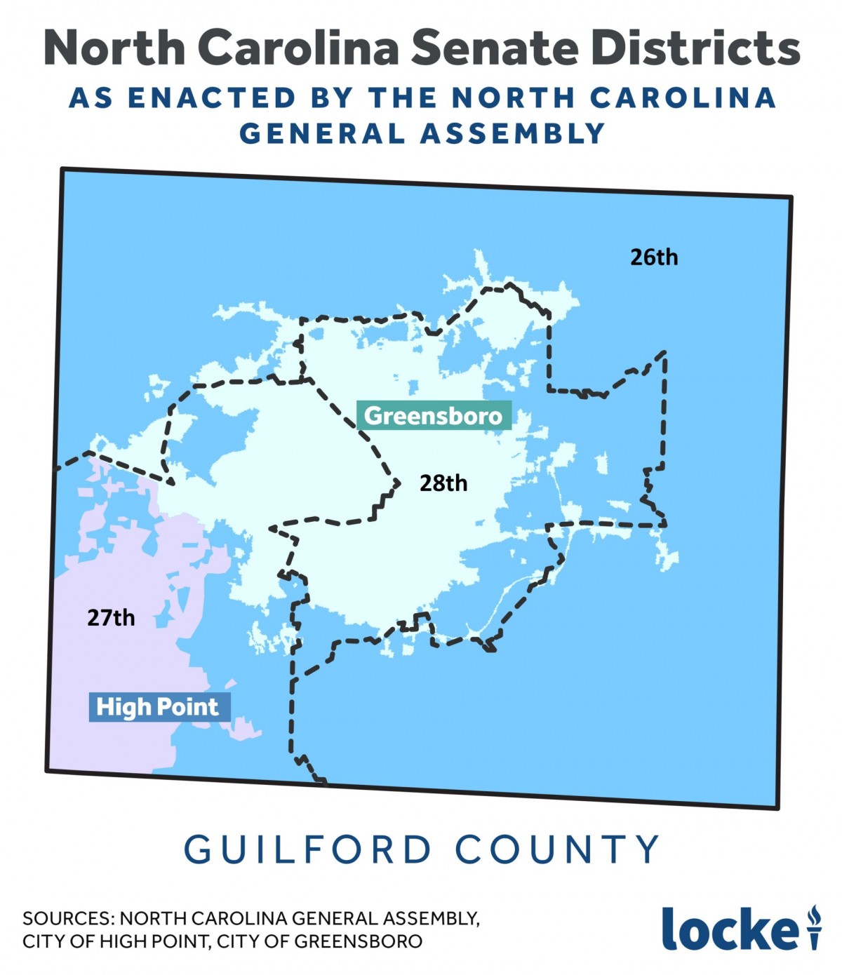
Cracking Downtown Greensboro into Three Parts
For example, we will see how the NCLCV's map cracks central Greensboro to subsume rural voters.
Under North Carolina's county grouping system, Guilford and Rockingham counties are placed together in a single cluster containing three North Carolina senate districts.
Greensboro, population 299,035, is the largest city in Guilford County and is too large to fit within a single North Carolina Senate district (ideal population 208,788), so it has to be divided once.
The map enacted by the General Assembly divides central Greensboro into two districts, with the bulk of precincts wholly contained in Greensboro going into the 28th District. The rest of those precincts go into the 27th. The 27th also includes High Point, the 9th largest city in North Carolina, located in southwestern Guilford County.
That means the 28th and 27th districts both represent urban and inner suburban interests. The remaining suburban and rural areas of northern and eastern Guilford County are placed in the 26th with rural Rockingham County. The 26th extends to suburban and rural southwestern Guildford (see Figure 1).
Figure 1 (Rockingham County portion of the 26th District not shown):
The NCLCV's map (
see appendix 199) also extends the 26th District to the suburban/rural southeastern portion of Guilford, befitting a district that includes Rockingham County. However, it also digs into downtown Greensboro, taking 11 precincts wholly contained in the city. As seen in Figure 2, the three districts converge in central Greensboro. In addition, the map extends the two urban districts into rural parts of northern Guilford County.
Figure 2 (Rockingham County portion of the 26th District not shown):
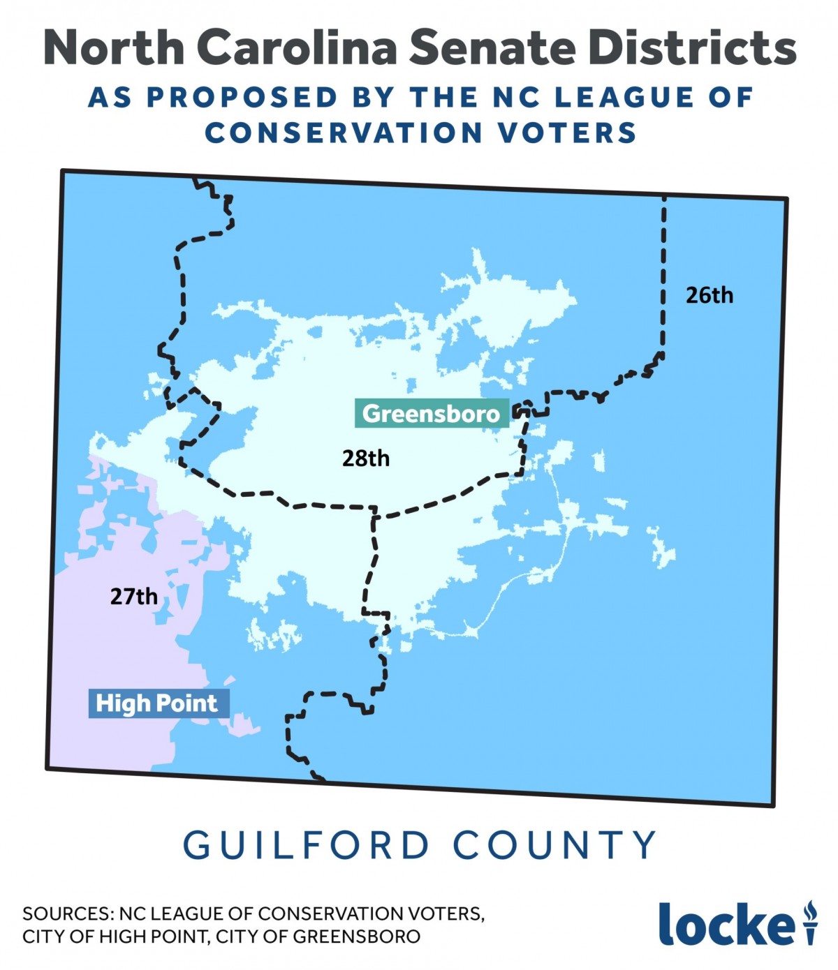
Table 1 shows how the precincts that are wholly contained within Greensboro as distributed in the two maps.
Table 1: Number of Precincts wholly contained within Greensboro in two North Carolina Senate maps
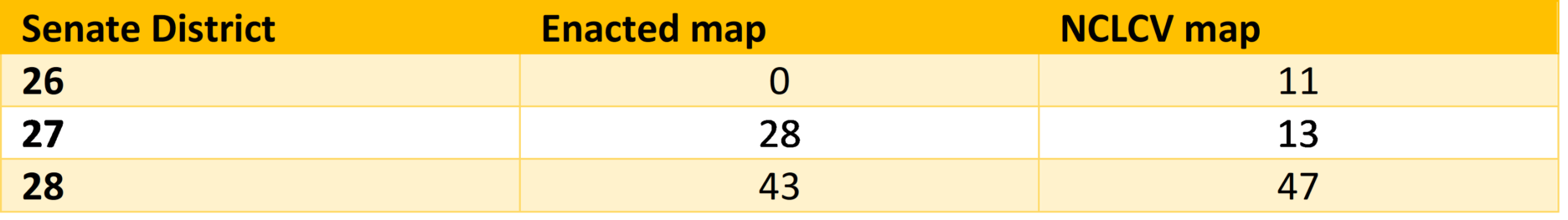
So, instead of two primarily urban districts and one mainly rural district, the NCLCV would have judges make that county grouping be composed of three districts containing central Greensboro.
Do voters in downtown Greensboro have more in common with other voters in Greensboro or voters up in rural Rockingham County? Why would the NCLCV seek to unnecessarily divide Greensboro like that?
A look at the enacted and NCLCV proposed remedial maps on Dave's Redistricting shows why. In the map enacted by the General Assembly, the 27th and 28th districts tend Democratic while the 26th tends Republican. In the proposed remedial map from the NCLCV, however, all three districts would tend to elect Democrats.
This is Just One Example
This is just one example. The NCLCV also proposes to crack central Asheville and Winston-Salem in North Carolina senate maps and cracks the central part of cities in their North Carolina House and Congressional maps (see their lawsuit appendixes for details).
By their own admission and actions in this lawsuit, the North Carolina League of Conservation voters is not seeking
"fair maps" but maps that would advance their lobbying efforts.


