Press Release:
Good Afternoon Everyone,
Our office continues to monitor the potential for a mix of winter weather on Wednesday and Thursday of this week. Please know that there continues to be a large degree of uncertainty with the current forecast. Subtle shifts northwest / southeast of expected precipitation and freezing temperatures could result in significant changes to our local impacts. Current details for Beaufort County include:
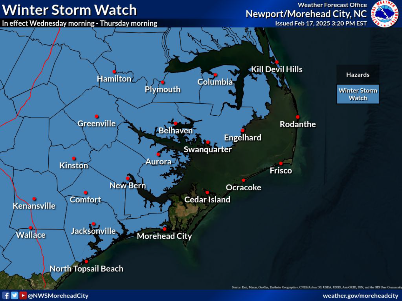
Watches / Warnings
- A Winter Storm Watch has been issued for our area, meaning that there is the potential for significant and hazardous winter weather within 48hrs.
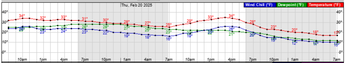
 Temperatures / Windchills
- Temperatures are expected to drop near or below freezing around 2am Wednesday morning and continue through 10am Friday, with daytime windchills between 20 and 25 degrees.
- Our coldest temperatures are forecasted to occur overnight Thursday with most areas reaching a low of 17 degrees (windchill of 10) around sunrise Friday morning.
Temperature (Red) & Windchill (Blue) Graphic: 8am Wednesday - 8am Friday
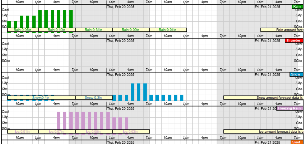
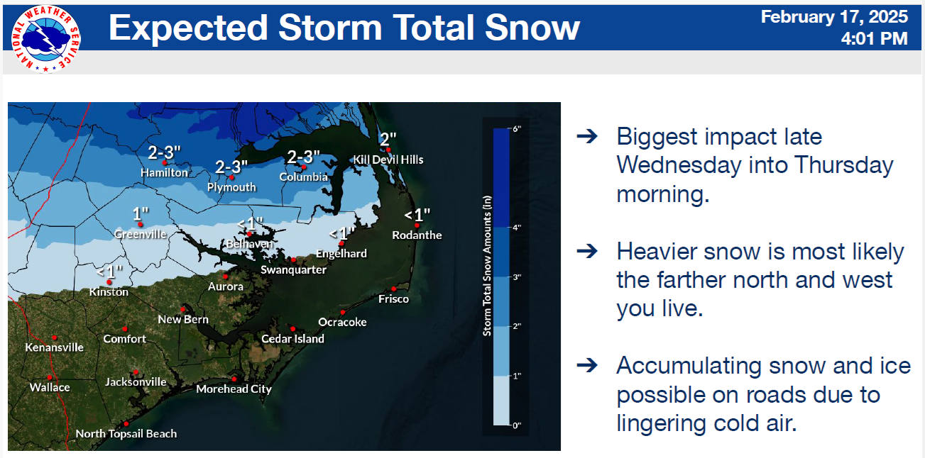
 Snow / Rain / Ice
Precipitation is expected to move into our area around 8am Wednesday and continue through noon on Thursday as outlined below:
Wednesday
- 8am to Noon: A mix of light rain and snow with minor accumulations.
- Noon to 4pm: Primarily rain (about 1/2 inch) with a mix of snow.
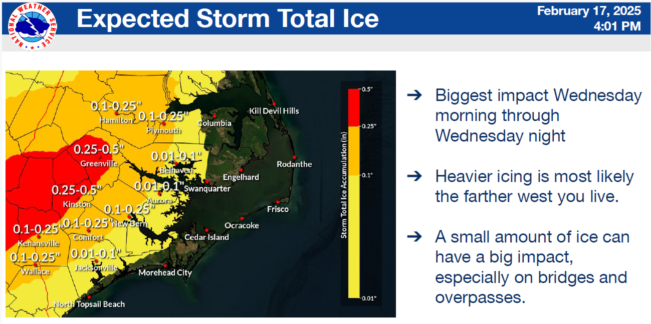
- 4pm to Midnight: A mix of freezing rain and snow, with areas west of Edward and Bayview receiving between 1/10 and 1/4 of an inch of ice.
Thursday
- Midnight to 7am: Primarily snow (less than an inch) with a mix of ice.
- 7am to Noon: Light snow flurries.
Rain (Green), Snow (Blue) & Ice (Pink) Graphic - 8am Wednesday - 8am Friday
Preparation Reminders
We encourage everyone to take the necessary precautions to safely protect you family, homes, and pets from the forecasted conditions over the coming days. Recommended precautions include:
- Utilize safe heating practices in your home. (Only use UL approved space heaters. Ensure heaters are at least 3 feet away from furniture and other combustible items. Make sure that you have working smoke alarms. Homes that utilize gas appliances should also have working carbon monoxide alarms as well.)
- Ensure exposed plumbing fixtures are wrapped to prevent freezing and familiarize yourselves with the location of your water shutoffs and / or water meter so that any leaks can quickly be shut off.
- Ensure that outside pets and livestock have adequate shelter to protect them from wind, rain, or frozen precipitation. Also ensure that they continue to have access to water that is not frozen.
Please see the email below and attached weather briefing from the National Weather Service for more information. We will continue to pass along updates as we receive them.
As always, thank you all for what you do to keep Beaufort County informed, prepared, and safe.
Chris Newkirk
Deputy Director
Beaufort County Emergency Services
1420 Highland Dr
Washington, NC 27889
Office: (252)940-6511
Cell: (252) 378-5352
Good Afternoon,
We have increasing confidence that a winter storm will impact Eastern NC Wednesday and Thursday. We have issued Winter Storm Watches for most of the area, for a combination of accumulating snow, sleet, and freezing rain.
Though the potential for wintry weather is high, there remains much uncertainty what
"type" of wintry weather will be seen in the counties of Eastern NC (whether that be sleet, freezing rain, or snow). This is because subtle track/forecast changes can have significant changes to the overall precipitation type. Please stay up to date with the latest forecast for snow/ice on our website here: https://www.weather.gov/mhx/winter
Our next briefing is expected to be sent out tomorrow morning around or before 9 am.
NWS_Morehead_City_Briefing_2_for_Winter_Storm_February_19th_20th.pdf
Regards,
NWS Newport/Morehead City
NOAA - National Weather Service
Newport/Morehead City, NC Weather Forecast Office
533 Roberts Rd
Newport, NC 28570


