Press Release:
Good Morning Everyone,
There were no major changes in the forecast for our area with this morning's update. While much of Beaufort Co. could see a mix of rain and snow later today, impactful accumulations will remain to our north and west. However, there is a potential for patches of black ice, especially on our elevated roadways, for late tonight / early tomorrow morning, as any remaining standing water on these surfaces will likely freeze overnight. Forecast details can be found below.
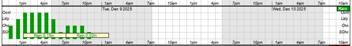
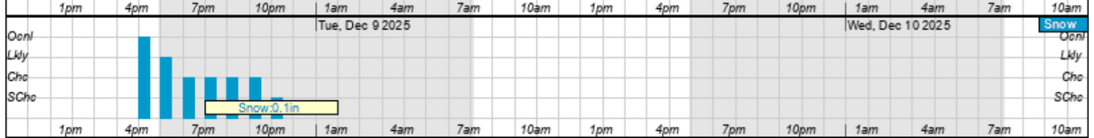
Rain & Snow
- Our rain chances will increase after lunch, with rain likely through 4pm. However, this rain will be light, with most areas receiving less than 1/4".
- A mix of rain and snow is possible between 4pm and 10pm this evening, with most areas receiving less than 1/10th of an inch of precipitation during this time.
Rain Graphic
 Snow Graphic
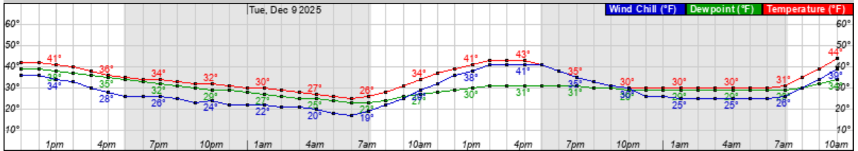
 Freezing Temperatures
- Temperatures are expected to be near or below freezing from 7pm this evening through 9am tomorrow morning.
- Again, these overnight temperatures will create the potential for patches of ice on our elevated roadways.
Temperature Graphic
Please see the email below and attached briefing from the National Weather Service (NWS) for more information.
We encourage everyone to continue to monitor TRUSTED media outlets for updates.
As always, thank you all for what you do to keep Beaufort County informed, prepared, and safe.
Chris Newkirk
Director
Beaufort County Emergency Services
121 W 3rd St.
Washington, NC 27889
Office: (252)946-0079
Cell: (252) 378-5352
Good morning,
Confidence is high that we will see a light snow event today (12/8) for portions of Eastern North Carolina. Rain moving in late this morning will change to a wintry mix and then to snow from NW to SE across the area in the afternoon. A Winter Weather Advisory remains in effect for Martin, Pitt, and Washington counties, which have the highest potential for snow accumulations. Snowfall totals have decreased slightly since the last briefing, with accumulations across these counties forecast to be less than 1" (locally 1-2").
Initially, snow will be difficult to accumulate until temperatures fall to near freezing late this afternoon. Slippery roads are possible for the afternoon/evening commute in the Advisory areas with snow lasting into the early overnight hours. Farther to the south and east, rain will mix with snow and could become all snow for a period of time before precipitation tapers off, but snow accumulations elsewhere in ENC (outside of the advisory areas) will be minimal (dusting) to none. A plain rain is expected across the Outer Banks and southern NC coast throughout the event.
Lastly, temperatures will fall into the 20s tonight into tomorrow morning away from the coast and OBX, bringing a black ice threat for the Tuesday morning commute given the wet ground and cold temperatures. Additional headlines may be needed for this threat later today.
This will be the last briefing unless conditions warrant additional updates.
NWS_Morehead_City_Briefing_2_for_Light_Snow_Monday_12_8.pdf
Regards,
NWS Newport/Morehead City
NOAA - National Weather Service
Newport/Morehead City, NC Weather Forecast Office
533 Roberts Rd
Newport, NC 28570


