It's that time of year again for North Carolina, hurricane season. The time of the year when tropical cyclones form in the Atlantic Ocean is from June to November, peaking in early September. On average, there are about six that actually reach hurricane intensity per year in the Atlantic basin. Generally, hurricanes are North Carolina's main storm source of potential destruction for the entire year. However, since last year's season, the state has endured floods, snow and ice storms, and
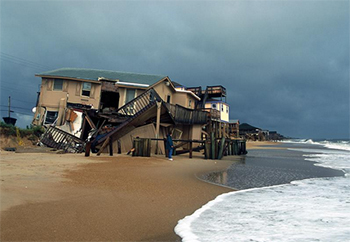
most recently a string of devastating tornadoes. Most NC residents that have been through a hurricane know the proper precautions to take and have a general knowledge of what to expect. Those who have not experienced a hurricane are often confused, scared, and have no idea what to expect, where to go, or how to prepare. Then there are those that think they're prepared, but don't realize all they actually need to do, or there are those that disregard the potential risk and believe that they will go unaffected and then lose everything.
Being well prepared when a storm is coming into your area is crucial. It is especially critical to have a plan and be prepared when it is hurricane season. When a hurricane starts to head towards land, the stores quickly become packed with people and all the water, milk, and batteries are swept off the shelves. Around this time of year, having a plan and kit put together, or easily gathered, will help to save time, money, and potentially lives. Some things to have in mind include having a family plan, a disaster supply kit, having a place to go, securing your home, and a pet plan if applicable. There are several things that can be done to be prepared when a hurricane is approaching. Properly securing your home against wind damage can save your home from having windows destroyed which can lead to an extensively larger amount of water damage as well as leaving it vulnerable to having it be completely

destroyed. Please follow these links to see what you can do to be as well prepared as possible during this hurricane season.
Family Plan
Supply Kit
Where to Go
Secure your home
Pet Plan
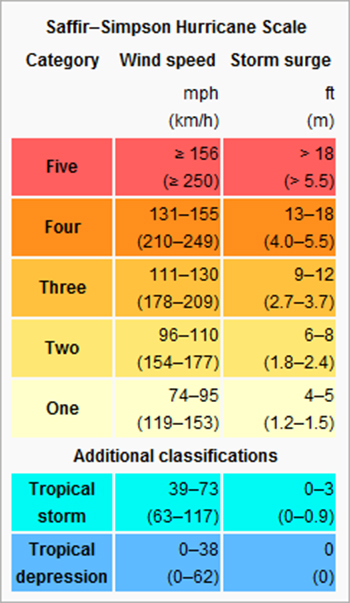
There are several levels before a storm becomes classified as a hurricane; once it matures there are five basic categories that they will fall under. Pre-hurricane storms are, ordered in increasing in development, tropical waves, tropical depressions, and tropical storms. The categories of hurricanes increase with both wind speed and size of the storm surge area.
Tropical cyclones are low pressure systems that form over warm tropical oceans. The primary energy source for a tropical cyclone is the release of latent heat, which is most prevalent over warm ocean waters. A tropical cyclone in the Atlantic Ocean begins as an area of low pressure near the coast of western Africa or in the Gulf of Mexico. If the atmospheric and oceanic conditions are favorable, it can intensify into a tropical depression, then a tropical storm, and then a hurricane.
Tropical Waves are a type of atmospheric trough, elongated region of relatively low atmospheric pressure, and acts similar to a front. They are oriented North to South and move East/ West. They normally follow areas of sinking, intensely dry air, then humidity abruptly rises and the atmosphere destabilizes; causing showers and thunderstorms
and can lead to the formation of tropical cyclones.
A Tropical Depression may occur once a group of thunderstorms have come together under the right atmospheric conditions for a long enough time. Winds near the center are constantly between 20 and 34 knots (23 - 39 mph). A tropical depression is designated when the first appearance of a lowered pressure and organized circulation in the center of the thunderstorm complex occurs.
Tropical Storms are severe storms that develop offshore over tropical seas with less than hurricane force winds but with the ability to develop into a hurricane.
Tropical cyclones are referred to as hurricanes when their maximum sustained winds reach or exceed 74 mph (33 ms-1 or 65 kts). Hurricane intensity is further classified by the Saffir-Simpson scale, which rates hurricane intensity on a scale of 1 to 5, with 5 being the most intense. The Saffir-Simpson scale is shown in the table below.
This year's hurricane names are Arlene, Bret, Cindy, Don, Gert, Harvey, Irene, Jose, Katia, Lee, Maria, Nate, Ophelia, Philippe, Rina, Sean, Tammy, Vince, and Whitney. Hurricanes get their names from one of
6 lists, each are repeated every six years. A new name is put into the list when a storm has caused extensive damage and is retired. This year is a repeat of the 2005 list except for those that were retired: Dennis, Emily, Franklin, Katrina, Rita, Stan, Wilma. A few of the names on this year's roster have affected North Carolina in previous years, but didn't cause enough damage to be retired. Arlene was a tropical storm in 1959 with a max wind speed of 50 and a min pressure of 1000. Cindy has hit North Carolina twice; in 2005 it was category 1 with a max wind of 65 and a min pressure of 992. Before that, it was a category 1 in 1959 with a max wind speed of 65. Ophelia was a category 1 in 2005 having a max wind of 75 and a min pressure of 976. The last one to affect NC was an unnamed tropical depression in 2009 with max winds of 30mph, and a min pressure 1006.
The following is a list of websites that may be helpful for further information on hurricanes and how to be better prepared.
Hurricane preparedness
National Hurricane Center
State Climate Office of North Carolina - Hurricanes
The Saffir-Simpson Hurricane Wind Scale


