News Release:
Good Afternoon Everyone,
The latest update from the National Weather Service (NWS) can be found in the email below and attached briefing. Notable changes to the forecast for Beaufort County included:
- The timing of precipitation has been delayed, and amount has been reduced.
- A northern shift in the snow line, resulting in changes to the anticipated snow accumulations for areas of Beaufort County.
Details of how these changes impacted the forecast for Beaufort County have been highlighted below. While forecast models are beginning to merge in likeness, they are still not in agreement as to snow accumulations, so forecasted totals could continue to change, especially over the next 12 to 24 hours.
Current Beaufort County Forecast
 Precipitation
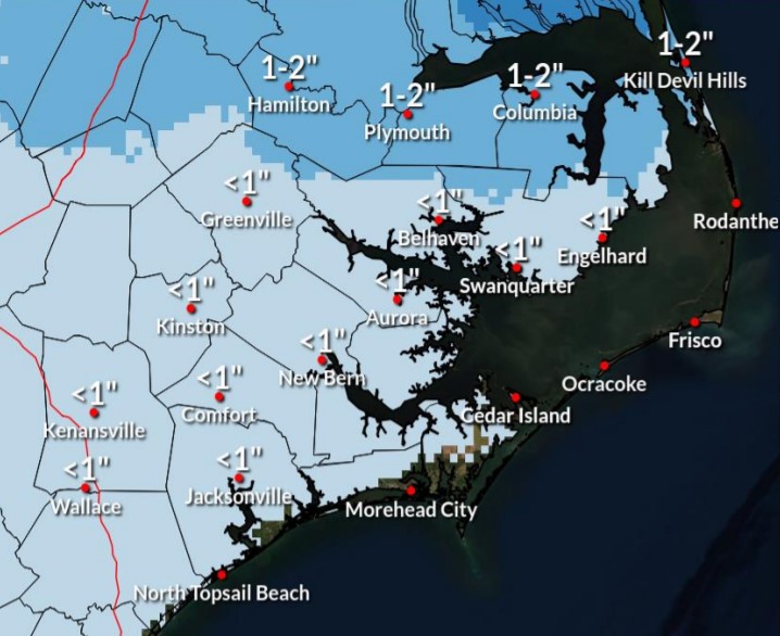
Rain chances will begin to increase after 4pm Friday, with rain likely after 7pm. A transition to snow is expected after 2am Saturday morning for most areas of the Beaufort County, and continue through 10am. Beaufort County is now forecasted to receive less than 1 inch of snowfall, with areas along our northern border receiving 1 to 2 inches. Our heaviest, and most widespread snowfall is expected to occur between 7am and 11am Saturday morning.
Winds
North winds will begin to increase after sunrise Saturday becoming sustained between 10 and 20 mph, and continuing through the daylight hours. Frequent gust between 20 and 30 mph are expected during this time. North winds between 5 and 10 mph will continue through noon Sunday before transitioning to the south throughout the afternoon.
These winds along with below freezing temperatures will create windchills in the low twenties through sunset Saturday, and single digits through noon Sunday.
Anticipated Hazards / Things To Prepare For
- Dangerous Road Conditions: We anticipate road conditions will deteriorate quickly Friday night and remain treacherous through the weekend as temps are expected to remain at or below freezing through Monday. We encourage everyone to avoid any unnecessary travel during this time.
- Power Outages: While this system is not currently forecasted to pose a significant ice hazard, power isolated outages are still possible and expected. Please ensure that you, your family, friends and neighbors are prepared to withstand cold temperatures and other winter elements in the event of a power outage.
- Cold Temperatures: Again, temperatures are expected to be at or well below freezing Saturday and Sunday. Please make the necessary arrangements to provide safety for outdoor pets / livestock, and protect any vulnerable infrastructure such as exposed water lines from freezing. We also encourage everyone to dress appropriately when going outdoors, and use caution when walking on frozen surfaces such as sidewalks, driveways, entry steps, etc.
The NWS will be hosting a series of live webinars pertaining to this storm as follows:
- Friday January 28th at 900 AM
You can register for all of the webinars using this same
link.
Our next update is scheduled for 6pm today. We encourage everyone to continue to monitor local media outlets for more information.
As always, thank you all for what you do to keep Beaufort County informed, prepared and safe.
Chris Newkirk
Deputy Director, Beaufort County Emergency Services
1420 Highland Dr
Washington, NC 27889
Good afternoon,
We made adjustments down in expected snowfall amounts across Eastern NC. We are now expecting up to 1 to 2 inches generally north of US Hwy 64, with some isolated amounts up to 3 inches possible for areas adjacent to the Albemarle Sound. Please continue to utilize www.weather.gov/mhx/winter, where you can see a reasonable worst case scenario, along with various snowfall thresholds both on a map or in a table.
We still expect snowfall/travel impacts to hold off until well after the evening commute Friday.
Wrap-around snow showers may bring some very light accumulations to the rest of Eastern NC Saturday morning, but these amounts should be under 1 inch, with most places receiving a dusting/coating to a half inch or so.
Regards,
NWS Morehead City
NOAA - National Weather Service
Newport/Morehead City, NC Weather Forecast Office
533 Roberts Rd
Newport, NC 28570


