Knowing where you are is very important when you need fire support, but it is more important that the
fire support crew know where you are. My recent post about the calligraphy master prompted Stan to mention that he was once in the drafting and Surveyor business.
Here is the link to that article. It reminded me of some of the hand drawn maps I have in my Vietnam File. I am reluctant to publish some of my Vietnam diaries here but this may help to illuminate the old days before GPS and pinpoint bombing became the norm.
Every army since time began probably used some form of map to

determine their location as well as the enemy's location. Long before GPS was the standard, the map was the most important part of planning and executing maneuvers. It may still be.
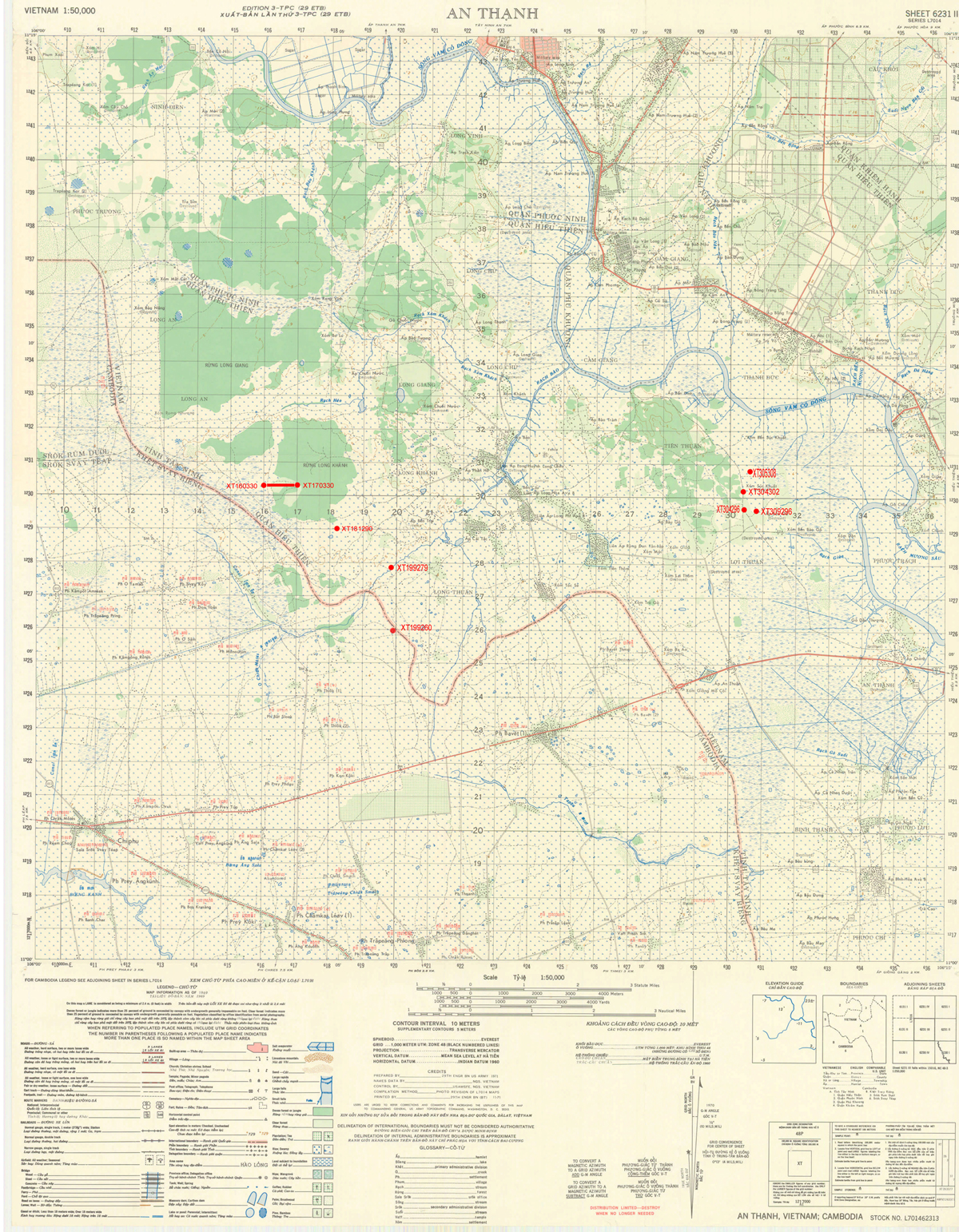
During my time in Vietnam, we used the Army tactical maps to mark and plot our unit's missions. Unit operations were coordinated using maps that displayed terrain, vegetation, and structures on a scale of 1:50,000. At that scale, one and 1/4 inch represented approximately one mile. Each map grid square is 1,000 x 1,000 meters (usually referred to as a Klick for kilometer). The rule in map reading is to "read right and then up." For example, the coordinates XT304296 on the map to the right is used identify the location of a major battle on April 4, 1968. The six digit coordinate would locate a point within 100 meters. The precision of a point location is shown by the number of digits in the coordinates: the more digits, the more precise the location.That's why you usually call for a marking round before unleashing the HE (High Explosive) rounds. After all 100 meters leaves a lot of room for error.
Click here for a larger version of the Tactical map.
3029- a 1,000-meter grid square.
304296- to the nearest 100 meters.
30452965- to the nearest 10 meters.
Here is a tactical map of my Area of Operation (AO) while in Vietnam. I have plotted several of the major battles my unit was involved in during my tour.
Below are some hand drawn maps of various base camps that were in our AO.
Dau Tieng
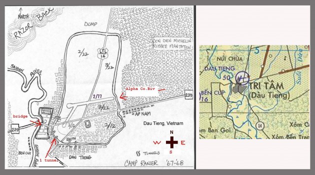
There are maps and there are maps. Here is a map of our one of our Base Camps in Vietnam, which I think was drawn by our resident artist, Wild Bill Hauser (I could be incorrect here as my memory is faded). This was drawn free hand using the topo maps of the Army as a guide. He drew it after he returned from Vietnam based on memory and consultation with others
Wild Bill also drew caricatures of most of the guys in the unit, but unfortunately, I lost mine during the years of denial and repressed memories.
Naturally, the Army in all its wisdom decided that Wild Bill was more valuable as a grunt than a mapmaker or cartoonist.
Cu Chi

Here is a map of Cu Chi, which was much more detailed and based on some Army maps. I am not sure that Wild Bill drew this one This was the Headquarters camp of the 25th Infantry Division and was like a mini city. I have forgotten the details of how this map came to be but I am sure it was not done in country since it would be a great mortar plot map for the enemy.
Nui Ba Den
There was a mountain in my AO (Area of Operation) in South Vietnam that stood out because it was the only high ground for miles around. Vietnam had such a diverse terrain but my AO was mostly rice paddies, jungles, and rubber plantations. The mountain was The Black Virgin Mountain based on some ancient Vietnamese legend. It real name was Nui Ba Den and it was 986 meters high. It was a communication and relay center. Because of its height, it was a coveted military target. We controlled the base and the top and the VC controlled the middle. It was heavily vegetated with jungle and forest.
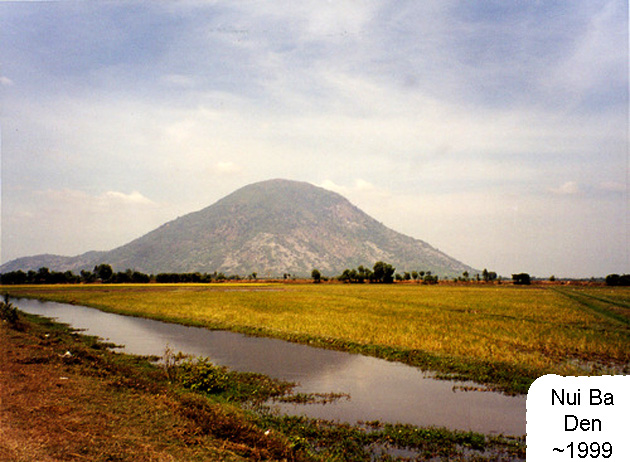
It was a constant target of the VC and was over ran several times during my tour. The VC would often probe the perimeter during the night. There was a series of bunkers around the mountaintop. In the center was a mortar pit where we would fire H&I's (Harassing and Interdiction fire) randomly during the night. One such time was May 1968. I was part of the relief unit that was sent to reclaim and secure the mountain after it was over run.
Here is a link to a short video showing some scenes on the mountain.

The bunkers were numbered and connected by landlines to the FDC (Fire Direction Center) as well as by Radio. During the night, a bunker could call in for illumination flares, which would light up the area for observation. If they saw something, they would call in for HE (High Explosive) fire in the area.
The FDC plot boards mapped the entire area with azimuth and distance fire parameters documented. A good mortar crew could set up and execute a fire mission within less than a minute after receiving the call. They could adjust the fire in a 360-degree circle to cover the entire mountaintop.
Some would ask how one would remember such things? The best way to cement something in memory is to attach some emotional baggage to the memory. Think about your childhood neighborhood, I will bet most could sketch the two-mile radius without consulting a map.
Several of my comrades have revisited Vietnam in recent years and visited the locations using their old maps as reference points. Vietnam today is nothing like it was in the 1968 era, but then nothing much else in the world is the same either. I never had an urge to revisit Vietnam. When people ask me if I ever wanted to revisit Vietnam my answer is "Nope! I did not lose anything there but my innocence, and I am pretty sure it is not there anymore".
Today Nui Ba Den is an amusement park with a gondola system people can ride up and down the hill. There is also a slide way, which is winding track ride that drops 1700 meters around the mountain. Good for them, the Vietnamese needed a break from the endless wars that tore their country apart.
As you might suspect, many Nam Veterans have tried to research the battles and places of their tour. I am guilty of this as well. I think it is part of trying to exorcise the demons as well as document what was for most, the most traumatic time of their lives. Most non-combat veterans get tired of hearing about the experience and just wish you would stop living in the past.
The Eagles had a song on their album 'Hell Freezes Over' released: 1994. The song
"Get Over It" expresses the advice to just grow up and move on. Here is an extract of the lyrics to that song.
It's like going to confession every time I hear you speak
You're makin' the most of your losin' streak
Some call it sick, but I call it weak
You drag it around like a ball and chain
You wallow in the guilt; you wallow in the pain
You wave it like a flag, you wear it like a crown
Got your mind in the gutter, bringin' everybody down
Complain about the present and blame it on the past
I'd like to find your inner child and kick its little ass
Get over it
Get over it
All this bitchin' and moanin' and pitchin' a fit
Get over it, get over it
Glenn Frye and Don Henley
Take my word for this. That is much easier said than done.


