Press Release:
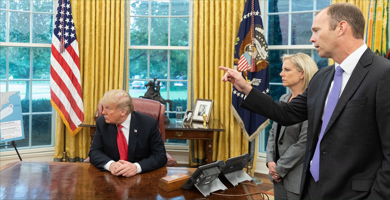 President Trump (left) DHS Secretary Kirstjen Nielsen (center) and FEMA Administrator Brock Long (right) discussing Hurricane Michael with : Above. (White House photo) Click image to expand.
Oval Office • October 10, 2018 • 12:12 P.M. EDT
SECRETARY NIELSEN:
President Trump (left) DHS Secretary Kirstjen Nielsen (center) and FEMA Administrator Brock Long (right) discussing Hurricane Michael with : Above. (White House photo) Click image to expand.
Oval Office • October 10, 2018 • 12:12 P.M. EDT
SECRETARY NIELSEN: All right, so I wanted to update you on Hurricane Michael. It's about 40 miles off the coast. It's starting to feel the effects now. It is a very dangerous Category 4. Just to remind the press, Hurricanes Harvey, Irma, and Maria were Cat fours. So these are big storms that we're looking at.
So it'll hit the Panhandle, as you can see on this one right here, sir. And then it will go through Georgia and the Carolinas. Unfortunately, on the tail end, we do expect additional rain in the Carolinas, which could lead to additional flooding.
FEMA is leaning forward, as we are with our interagency partners. We're forward deployed. We have search and rescue ready to go. We're in very close contact with state and local authorities. We've all spoken with the governor and local officials.
And I'll turn it over to Brock to give additional details.
ADMINISTRATOR LONG: Thank you, Secretary. Unfortunately, this is a Gulf Coast hurricane of the worst kind because all of the elements associated with hurricanes come into play.
So, as you see on the left, the storm surge estimates are anywhere between 9 and 14 feet. The storm surge is going to be the worst where the eye makes landfall - just to the east or south of where the eye makes landfall. Somewhere right now, it's projected between Panama City, Apalachicola, and then it's going to push forward.
So not only is it going to bring 14 feet of ocean water and coastal flood inundation, there will be wave action on top of that, which is the primary driver of why we evacuate, sir.
And then, coupled with that, you've got over-145-mile-per-hour winds. You know, structures built before 2001 are not designed to handle that type of wind, typically.
And it's going to, unfortunately, push through the states. So we're asking citizens in southwest Georgia, central Georgia to be vigilant and to make sure that they understand what's about to come - because this area is going to see a Cat 1, Cat 2 storm as it moves inland. And with the vegetation there, what we're anticipating is a lot of downed trees impacting the power grid.
And here, again, we're going to see a lot of devastation along the coast, structurally. And then, as it moves in, you're going to see power outages throughout the state.
And then, unfortunately, you're going to see rainfall into South Carolina and North Carolina. The Cape Fear was projected to start receding from Hurricane Florence two days ago, and this will basically exacerbate the problem and add to it a little bit, to where it's going to keep those waters from receding a little bit as it exits the state by Friday.
THE PRESIDENT: So they're reporting that this is one of the most powerful hurricanes ever to hit our country. Is that actually a fact?
ADMINISTRATOR LONG: Well, you know, so in this area, this would be the most intense hurricane that has struck this area since 1851, if I remember correctly. So -
THE PRESIDENT: A long time.
SECRETARY NIELSEN: This is a big storm.
ADMINISTRATOR LONG: Yes. Intense. Very intense. But -
THE PRESIDENT: And this one is going to heavy rain or is it going to be the winds that are going to be the problem?
ADMINISTRATOR LONG: Storm surge and winds. And then for Georgia, they're going to see high inland winds, so you may see sustained Category 1, Category 2 winds with higher gusts that are associated.
So we're expecting a lot of damage inland as well. But we have leaned forward with Governor Scott and his staff, and Director Wes Maul down in Florida. They've been leaning forward as well.
And right now, there's no identified shortfalls when it comes to pre-positioning. So we have teams, equipment, personnel not only with and embedded with state-of-Florida staff and some of the local county emergency managers. But we have equipment teams staged in Maxwell, to Atlanta, to Orlando ready to move in once we can - once the elements subside and push through, and then we can move in and attack.
SECRETARY NIELSEN: And we're working really closely with the private sector. So they've got 14 states - different utilities from 14 states are already ready to -
THE PRESIDENT: Yeah, (inaudible).
SECRETARY NIELSEN: - are ready to help with any energy outages.
THE PRESIDENT: Electric companies are from all over the country, actually. They're all lined up. As soon as it goes by, they're going to be working. And we've got food supplies, food chains. We're working with all of the states.
And let me ask you: This started out very innocently a week ago. This was a small storm in an area they never thought. They said it grew into a monster.
ADMINISTRATOR LONG: Right. So the first initial indications from the National Hurricane Center started coming in around Saturday. And they picked it up and started raising the flag that, "Hey, this system is going to go from a wave to a depression, and it could potentially rapidly intensify." And unfortunately, that's typical of the Gulf Coast.
And when they do this, those citizens have less time to prepare or heed the warnings. We are concerned that many citizens chose not to heed those warnings, but we're prepared with search and rescue teams to try to go in and do what we can.
THE PRESIDENT: Any questions for us?
Q Yes. Are you concerned that the folks in Florida and Georgia in the storm's path aren't prepared enough and that there aren't enough evacuations, to follow up on that point?
ADMINISTRATOR LONG: Yesterday, we were concerned that we were not - we did not like the level of evacuation activity that we were seeing. And, you know, Governor Scott - kudos to him. He leaned forward, used the new wireless emergency alert capabilities that we have, and sent out a text - you know, text messaging last night. Leaned forward and said, "Hey, get out of there."
And so we were trying to get people to really take the storm seriously. A lot of people did heed the warning, but then there are those who chose to stay behind. And unfortunately, first responders may not be able to go in and rescue those who dial 911 at this point.
Q Mr. President, can you give us a sense of the officials you've been in contact with? Have you spoken to the governor?
THE PRESIDENT: I have. I have And the other governors, depending on what happens here - but they are all either contacted or are in the process. I had a long talk with Rick Scott - Governor Scott, of Florida. Very well coordinated with all of the states.
And, you know, one of the things that must be said is it's not so easy for some of these people to leave. Some of the areas are very poor. It's not easy for a person without the necessary money to leave. So what we've done is we've sent buses. We've sent a lot of different - we're doing a lot of different things to try and remove people from the area. But a lot of people are very poor in certain of those areas, and it's very tough for them to leave. That's one of the problems you're finding, I guess, huh?
ADMINISTRATOR LONG: Yeah. In some cases, what we asked to do on blue-sky days is ask people, who may not have the means or the mechanisms to get out of town, to register with their local emergency management agencies - and Florida has been pretty robust in doing that - so that we have some idea of how to pre-plan for that.
And then we do what we can to be able to support the movement of people. When it comes to Georgia, you know, we're not evacuating for storm surge in Georgia. This is going to be high winds. So we're asking people to get within a facility that can withstand the winds, and try to shelter in place or seek out public shelters that may be open in southwest Georgia.
THE PRESIDENT: But if you look at the size - how long it is. Take a look at that. And the red area basically is the area where it's going to hit pretty heavily. And that's a - that's a lot of shore. That's a lot of land.
SECRETARY NIELSEN: Yes, sir. There will be four feet of storm surge all the way down to Tampa Bay - which, as you know, is very low-lying and floods very easily. But to give you that idea of the breadth of its path. It is quite large.
THE PRESIDENT: It's almost the entire size of the Gulf. When you look at it, topically, it's almost the entire size of the Gulf. And they haven't seen that. Maybe they haven't seen that at all. Nobody has seen that before.
ADMINISTRATOR LONG: The eye diameter is pretty wide, which unfortunately is not good news as it makes landfall. So some people may say it's similar to an EF3 tornado making landfall in areas that are close to the eye. So it's -
Q Did last year's hurricanes in the area impair the infrastructure or weaken it in any way that they would struggle to deal with this year's hurricane?
ADMINISTRATOR LONG: Not in this area. Irma did not really heavily impact the Florida Panhandle. Most of the hits from Irma was in the southwest portion of Florida, and then moved up through and created some issues in the Jacksonville area and the northeastern portion.
But this area has been a long time since it's been hit, so the vegetation hasn't been stressed. And we're going to see a lot of damage and devastation, unfortunately. And we have to set the citizens' expectations that the power is going to be out for a while. And what FEMA's role in that is, as the Secretary was saying, our partnership with the private sector is that we work with the Florida Power and Lights, the Gulf Powers, the southern companies - the Georgia Powers, to be able to help them facilitate their mutual aid to come in.
And they've got power crews coming in from multiple states across the country that are already pre-staged. And when we're hit, we work with them to do what's called "first push debris" to get the roadways open and so that we can get them down the roadways to start fixing the power. But that's going to take some time.
Q Mr. President, do you plan on changing any of your travel schedule (inaudible)?
THE PRESIDENT: Well, we don't know. I know was going to Pennsylvania. It looks like there are thousands of people already lined up, and probably will do that tonight. And we're going to go down here as soon as we can. We don't want to interfere with anybody, but we want to go as soon as possible.
You have - you know, right nearby we have thousands of people going tonight, and they've already - many are there already.
What time are we - were you going to be there? What time are we landing on that?
Q The rally tonight is scheduled for 7 o'clock.
THE PRESIDENT: Yeah, it's about seven.
Q Are you going to go ahead (inaudible)?
THE PRESIDENT: Well, I don't know what to do, because you have so many people already there, and it's sort of unfair to them. So it's a mix. I'll be totally focused on this. But we'll make a determination over the next little while. But you have people that -
Q Does it make it for difficult for you to pay attention to the storms -


