Press Release:
Good Afternoon Everyone,
Our office continues to monitor the developing forecast of a coastal low-pressure system that is expected to impact our area through the weekend. Today's update includes minor timing and accumulation totals for this weekend's rain, and possible tracks for the passing low-pressure system. Updates to Beaufort County's forecast have been
underlined below:
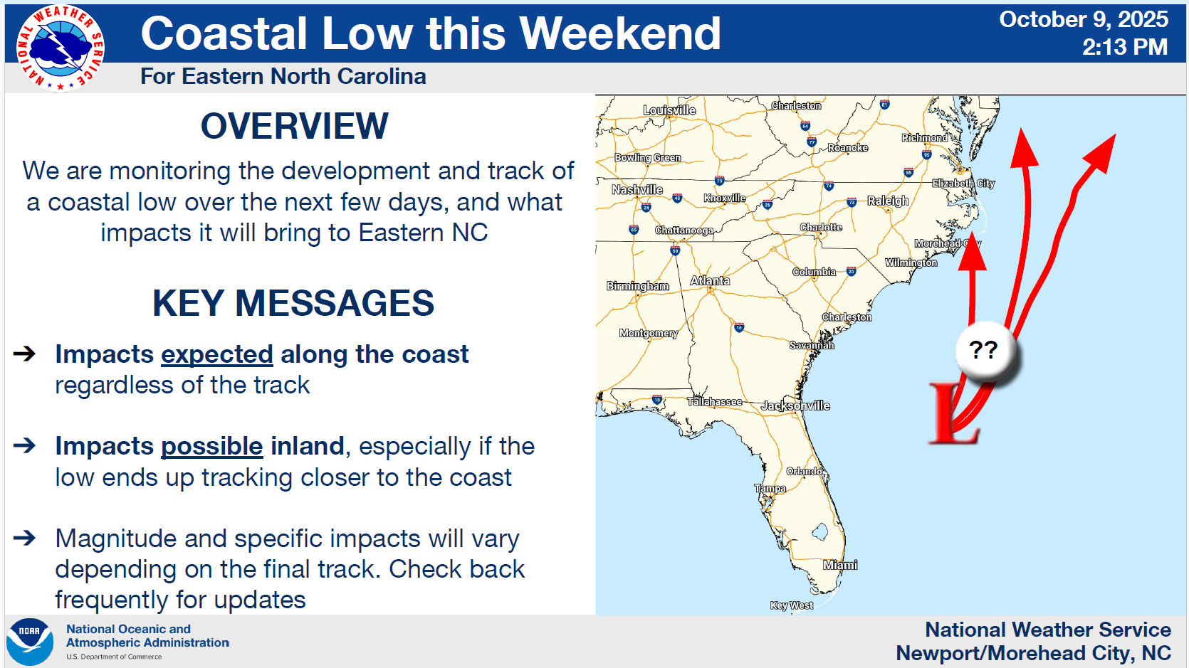
Forecast Track and Area of Uncertainty
Rain
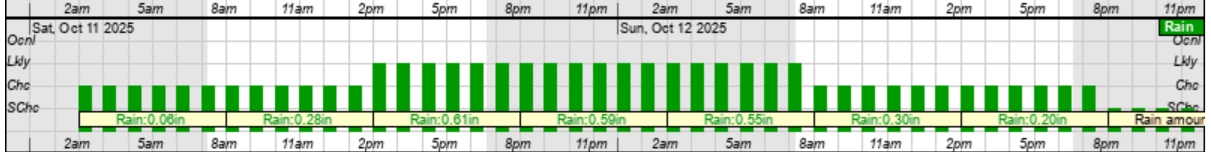
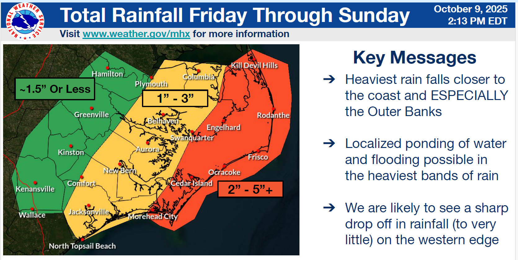
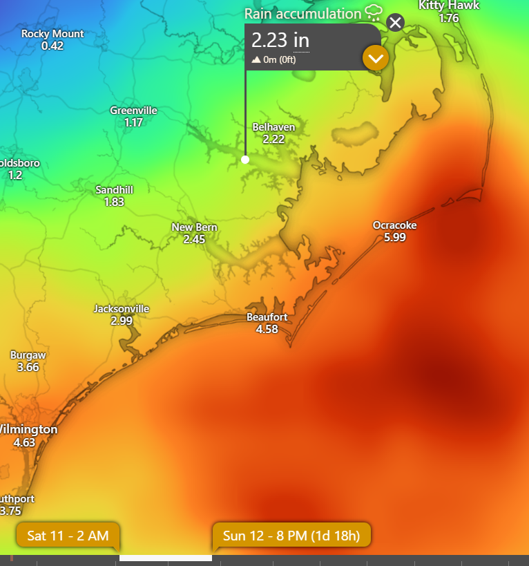
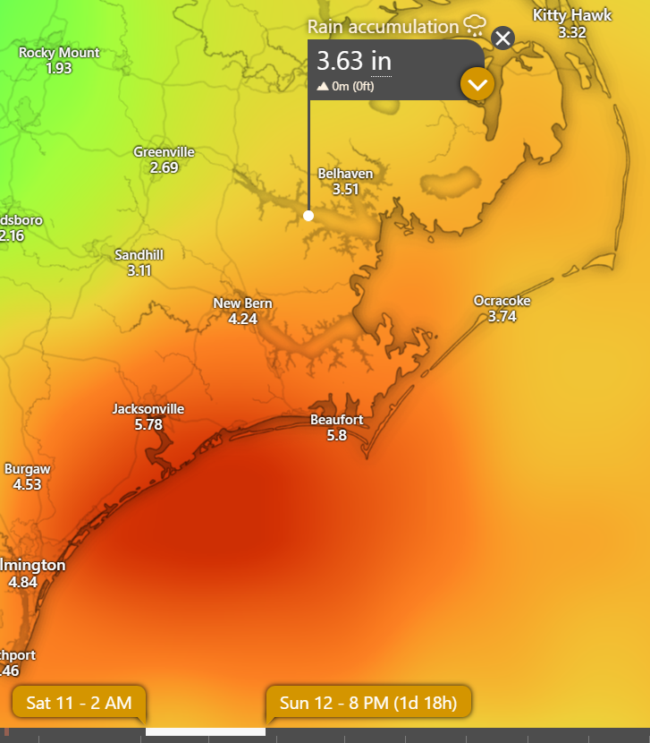
Rain will begin to move into our area around 2am Saturday morning and continue through sunset Sunday with most areas of our county currently forecasted to receive between
1 and 3 inches of rain. However, there continues to be discrepancies in the total rainfall amounts between some of the forecast models. (See the comparative graphics below.)
- This rain will begin as scattered showers through lunchtime Saturday, with widespread rain likely through 8am Sunday morning. Scattered rain is also expected throughout the daytime hours on Sunday.
- Our heaviest rain is expected to occur between 2pm Saturday and 7am Sunday.
NWS Hourly Rainfall Graphic for Saturday & Sunday
 Current NWS Total Rainfall Map
 EURO - Rain Total Graphic for Saturday & Sunday
 GFS Rainfall Total Graphic for Saturday & Sunday
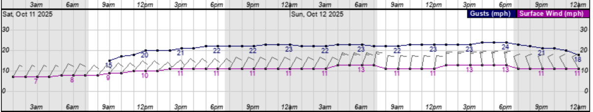
Wind
We are forecasted to experience sustained
7 to 15 mph Northeast / North winds,
with gust between 20 and 25 mph possible through midnight Monday. These winds will begin to transition to the Northwest early Monday morning.
- Our highest winds are forecasted to occur Saturday and Sunday, with frequent gust of 20 to 30 mph likely.
NWS Hourly Wind Graphic for Saturday & Sunday
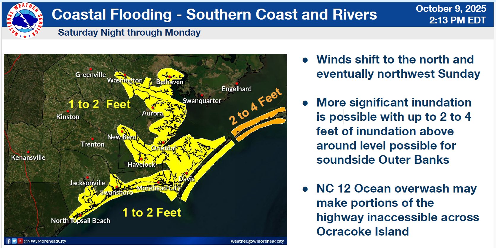
Elevated Water Levels
A Coastal Flood Advisory has been issued for our area through Monday, with water levels forecasted to be 1 to 2 feet above normal levels. Shorelines vulnerable to sustained northly winds and low-lying areas vulnerable to King Tides should expect these higher than normal water levels from Thursday to early Monday morning. These waterways should begin to return to normal levels as we move through the day on Monday.
Current Coastal Flood Advisory Map
Please see the email below and attached briefing from the National Weather Service (NWS) for more information.
We encourage everyone to continue to monitor trusted local media outlets for additional updates.
As always, thank you all for what you do to keep Beaufort County informed, prepared and safe.
Chris Newkirk
Deputy Director
Beaufort County Emergency Services
1420 Highland Dr
Washington, NC 27889
Office: (252)940-6511
Cell: (252) 378-5352
Good afternoon,
We are still expecting a long duration hazardous wind and coastal flooding event through Monday. Strong winds will continue into Saturday, before a potent coastal storm develops off the Carolina coast later in the day Saturday and remains with us into early next week bringing more significant impacts to the area.
Confidence remains HIGH that this storm will form, but its exact track and intensity still remain unclear. Confidence in strong wind gusts and heavy rain along the coast is increasing at this time. Hazardous marine conditions are expected through Monday.
Key Messages
- Due to gusty northeast winds, confidence is HIGH in minor to locally moderate coastal flooding impacts to portions of ENC through Friday.
- A strong coastal storm is expected to form this weekend, which has the potential to bring moderate to locally major coastal flooding impacts to some communities.
- King tides through this period will exacerbate impacts
- Heavy rain and areas of flash flooding are possible this weekend with the coastal storm. Areas along the coast have the highest chances of seeing heavy rainfall, rapidly decreasing as you move further inland.
Our next briefing is expected to be sent tomorrow by 9 AM.
If you have any questions or concerns please don't hesitate to reach out to us.
NWS_Morehead_City_Coastal_Impacts_Briefing_5.pdf.pdf
Regards,
NWS Newport/Morehead City
NOAA - National Weather Service
Newport/Morehead City, NC Weather Forecast Office
533 Roberts Rd
Newport, NC 28570


