Press Release:
Good Afternoon Everyone,
While this afternoon's update once again included increased probabilities of moderate to major impacts, it will likely be tomorrow before we receive specific accumulation details. Changes to our previous briefings have been
underlined below.
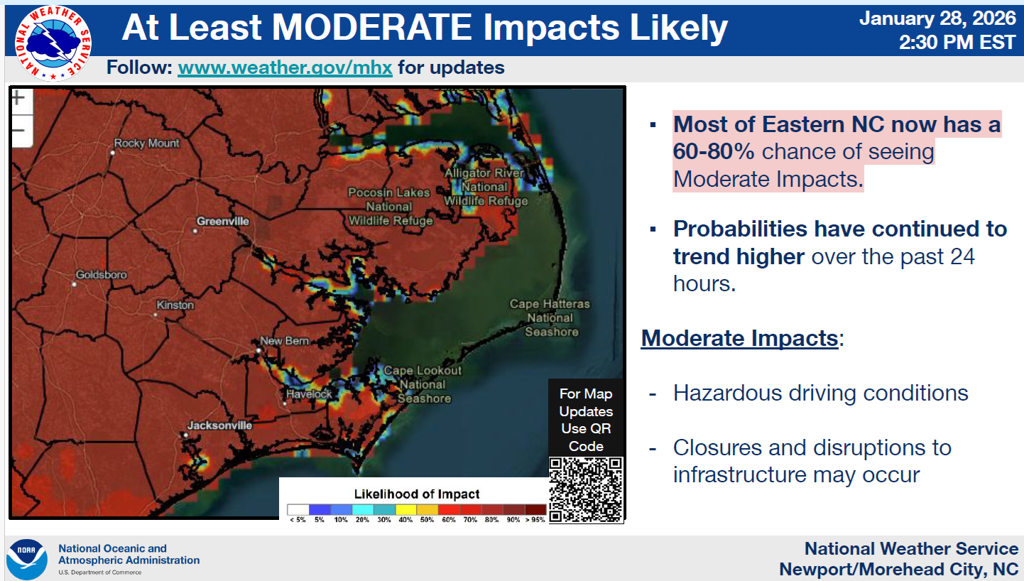
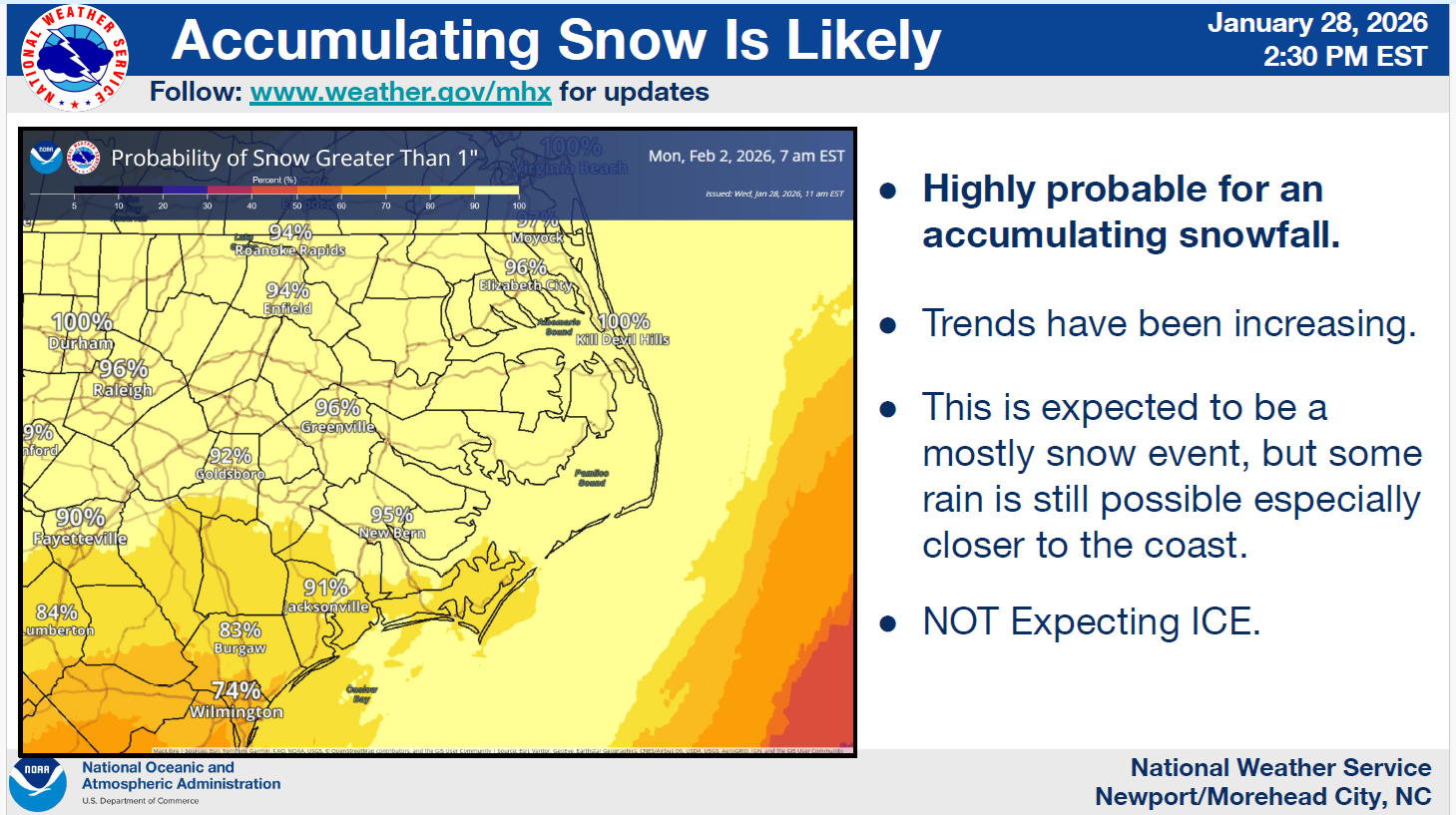
Probabilities of Moderate Impacts
We continue to have a 60 to 80% chance of experiencing
"Moderate Impacts" (hazardous driving conditions, closures, disruptions with normal daily activities, etc.) from this weekend's weather system, with a
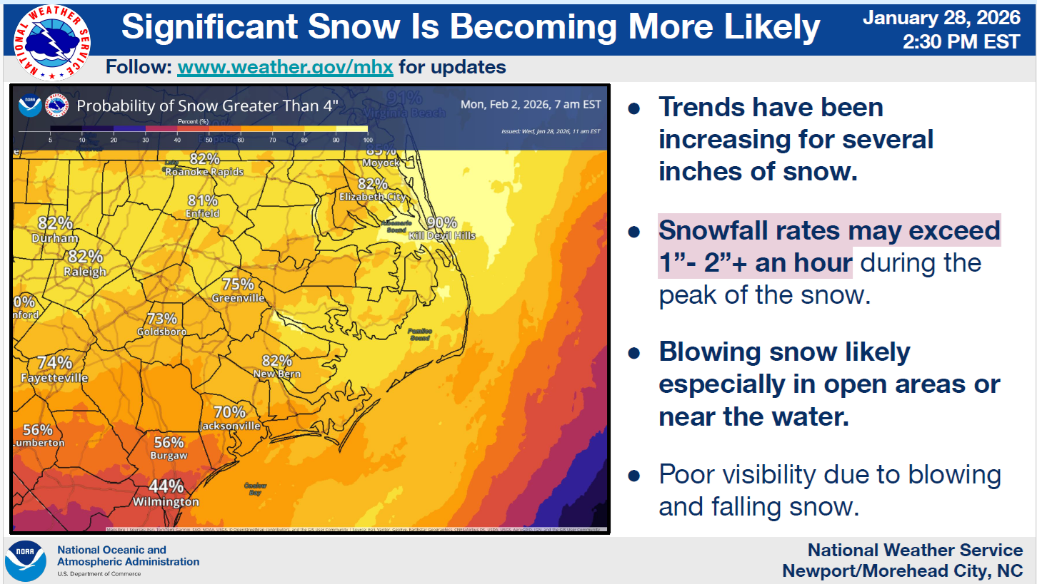
95% chance of receiving greater than 1 inch of snow and a
75% chance of receiving more than 4 inches of snow.
Moderate Impact Graphic (60 to 80%)
 Receiving More Than 1 inch of Snow Graphic
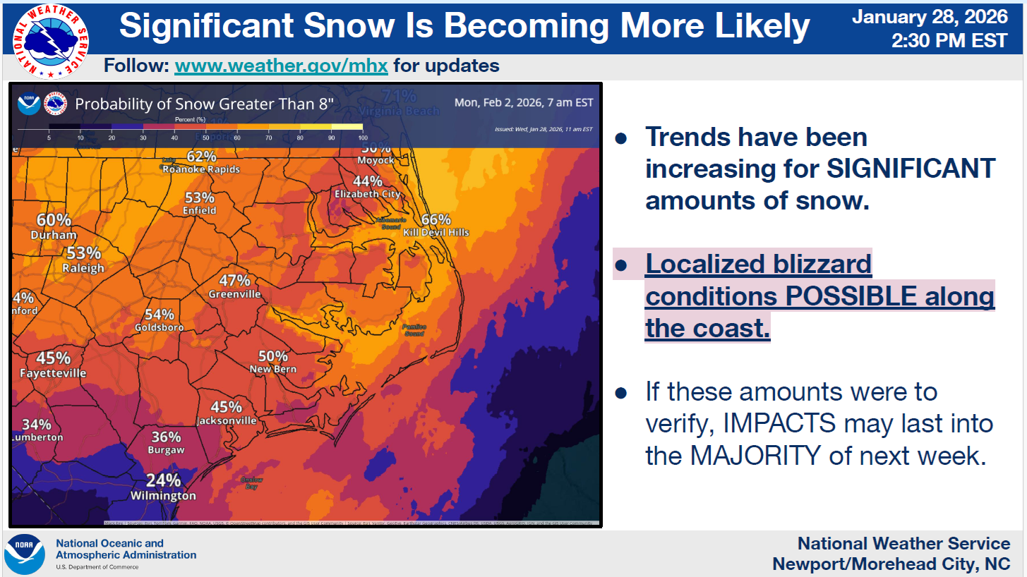
 Probabilities of Major Impacts
Most of Beaufort County now has at least a 50% chance of experiencing "Major Impacts" over the weekend, with a 75% chance of receiving greater than 4 inches of snow and a 50% chance of receiving greater than 8 inches of snow.
Receiving Greater Than 4 inches of Snow Graphic
Probabilities of Major Impacts
Most of Beaufort County now has at least a 50% chance of experiencing "Major Impacts" over the weekend, with a 75% chance of receiving greater than 4 inches of snow and a 50% chance of receiving greater than 8 inches of snow.
Receiving Greater Than 4 inches of Snow Graphic
 Receiving Greater Than 8 inches of Snow Graphic
 Timing of Impacts
Snow
Timing of Impacts
Snow
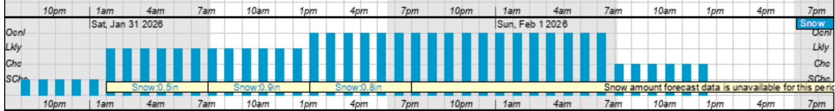
- Snow is currently forcasted to begin around 1am Saturday and continue through sunrise Sunday morning.
- Our heaviest snow is currently forecasted to occur between 1pm Saturday and 6am Sunday morning.
Hourly Snowfall Graphic for Saturday & Sunday
 High Winds
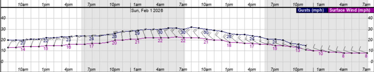
North and Northwest winds will begin to increase shortly after sunrise Saturday, becoming sustained between 15 and 20 mph, with frequent gusts of 25 to 30 expected through sunset Sunday.
Hourly Wind Graphic for Saturday & Sunday
High Winds
North and Northwest winds will begin to increase shortly after sunrise Saturday, becoming sustained between 15 and 20 mph, with frequent gusts of 25 to 30 expected through sunset Sunday.
Hourly Wind Graphic for Saturday & Sunday
 Temperatures & Windchills
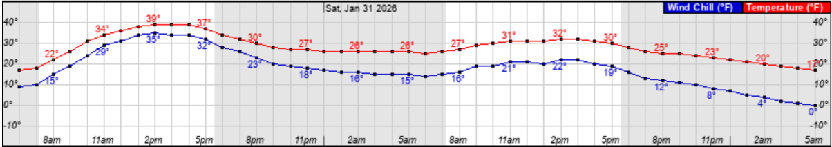
Temperatures are expected to drop below freezing around sunset Friday and remain near or below freezing through noon on Monday, with windchills between 15 and 20 degrees Saturday night and 0 to 10 degrees Sunday night.
Hourly Temperature & Windchill Graphic for Saturday & Sunday
Temperatures & Windchills
Temperatures are expected to drop below freezing around sunset Friday and remain near or below freezing through noon on Monday, with windchills between 15 and 20 degrees Saturday night and 0 to 10 degrees Sunday night.
Hourly Temperature & Windchill Graphic for Saturday & Sunday
What to Look for and Prepare For
While details related to possible accumulations of snow are uncertain, we encourage everyone to ensure that your family, friends, and neighbors take time over the next few days to monitor this evolving forecast and consider what actions you would need to take to be prepared for the following possible outcomes.
Impactful Snow Accumulations
- Do you have enough food, supplies and medicine to last several days (Saturday through Wednesday) in the event you are unable to travel due to hazardous road conditions?
- Are you prepared for isolated power outages? (How would you stay warm? How would you cook? Do you have battery operated lighting and a way to charge electronic devices?)
- Are your outside pets and livestock protected from hazardous winter weather conditions? (Do they have adequate shelter? Do they have access to water that is not frozen?)
Please see the email below and the attached briefing from the National Weather Service (NWS) for additional information.
We anticipate releasing our next update by 10am tomorrow morning.
As always, thank you all for what you do to keep Beaufort County informed, prepared and safe.
Chris Newkirk
Director
Beaufort County Emergency Services
121 W 3rd St.
Washington, NC 27889
Office: (252)946-0079
Cell: (252) 378-5352
Good afternoon,
Attached is our first multi slide briefing for the winter storm expected to impact the area this weekend.
- While it remains too early for specific snow accumulations, the likelihood of at least moderate to major (significant snow accumulations) impacts continues to increase.
- Very strong winds expected along the coast, which will likely lead to moderate to locally significant coastal flooding impacts (both oceanside and soundside).
- Very dangerous marine conditions expected across the coastal waters and sounds.
NWS_MHX_Briefing_5_Weekend_Winter_Storm.pdf
Regards,
NWS Newport/Morehead City
NOAA - National Weather Service
Newport/Morehead City, NC Weather Forecast Office
533 Roberts Rd
Newport, NC 28570


