

Our Community Platform providing Essential Information to Know what is Real


Misconceptions about Redistricting: What Are the Stephenson Criteria?


By requiring that counties be paired off for legislative districts and banning the previously used practice of transversing counties along multiple points, the Stephenson criteria limits the gerrymandering of state legislative maps. In effect, Stepheson makes map drawers have to section out their work. Rather than looking at the state as a blank canvas on which to draw districts, they must draw several pieces and make them fit together. This is why geography is essential in understanding legislative maps, as most of the state's Democratic voters fall within a few urban areas. A recent North Carolina Chamber article illustrated this by mapping the North Carolina 2022 U.S. Senate election result.
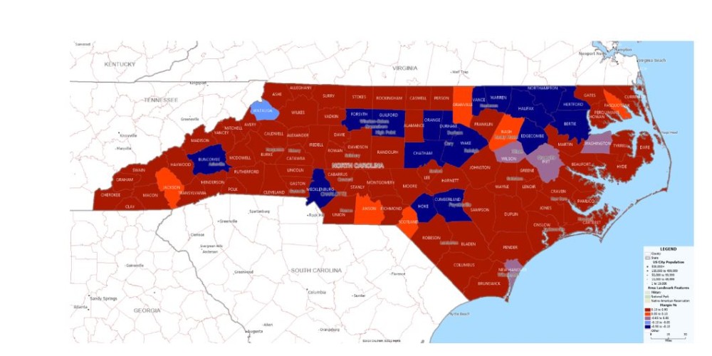
When we look at the demographic breakdowns and Stephenson's criteria on county clusters, we understand that a competitive state for statewide elections like North Carolina favors Republicans for legislative seats. In the recent redistricting case, the plaintiff's experts found the most likely outcomes for maps almost give Republicans a supermajority for the House and Senate based on the leans of the districts. The most likely result for the leaning of House districts is a 68-52 Republican map, while the Senate outcome is a 28-22 Republican-leaning map. This means Republicans would only need to win four toss-up/lean Dem seats in the House and only two in the Senate to get a supermajority.

In essence, even though Democrats have almost as many supporters, Republicans are likely to have maps favoring them in the state legislature. Democrat voters are heavily packed into major metropolitan counties, while Republicans have an advantage in the majority of suburban and rural counties. While land may not vote, the people on that land do, and how voters are spread out matters a lot for the purposes of these maps.
Go Back
When we look at the demographic breakdowns and Stephenson's criteria on county clusters, we understand that a competitive state for statewide elections like North Carolina favors Republicans for legislative seats. In the recent redistricting case, the plaintiff's experts found the most likely outcomes for maps almost give Republicans a supermajority for the House and Senate based on the leans of the districts. The most likely result for the leaning of House districts is a 68-52 Republican map, while the Senate outcome is a 28-22 Republican-leaning map. This means Republicans would only need to win four toss-up/lean Dem seats in the House and only two in the Senate to get a supermajority.

In essence, even though Democrats have almost as many supporters, Republicans are likely to have maps favoring them in the state legislature. Democrat voters are heavily packed into major metropolitan counties, while Republicans have an advantage in the majority of suburban and rural counties. While land may not vote, the people on that land do, and how voters are spread out matters a lot for the purposes of these maps.

Comment


Home
Contact
About
Service Rates
Privacy Policy
Follow on Facebook
Subscribe to Newsletters
Rss Feed
Keywords
Eastern NC Now & ENC NOW © Copyright 1998-2024 All Rights Reserved.

Yeah, I have done my part as the perfect Republican over all these decades.
Glad to know my work is still being discussed.