Publisher's note: The author of this post is Don Carrington, who is executive editor for the Carolina Journal, John Hood Publisher.
Politically connected acquired island with title problems
RALEIGH When two politically connected men began building new houses in 2013 on an island Dare County resident Bill Boykin purchased in 1997, Boykin concluded the chain of events leading up to the construction didn't pass the smell test.
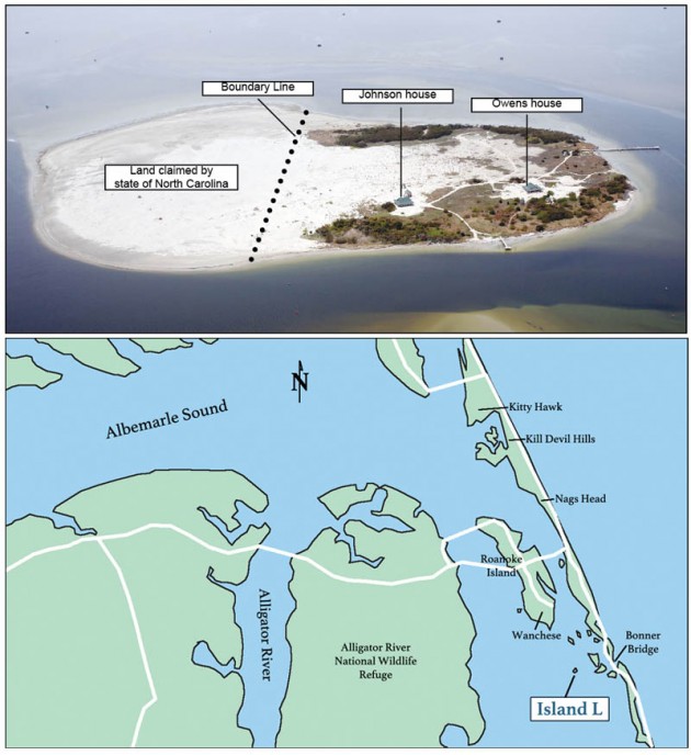
CJ Photo by Don Carrington/CJ graphic
Island L, looking west, in public records is divided between the state, Michael Johnson, and R.V. Owens III.
He had lost the island in a 2006 divorce settlement, but he became convinced that ownership of the island at the time he lost it was unclear, that the state's claim to own part of it is questionable, and that currently there are "clouds on the title."
The two men who built the houses - former Dare County Commissioner Michael Johnson and politically active Manteo businessman R.V. Owens III, a former member of the UNC Board of Governors and nephew of longtime Democratic Senate leader Marc Basnight - acquired the island from a convicted felon and registered sex offender who had acquired the island from Boykin's ex-wife.
The tale of the island's muddled ownership began in 1996 when a friend from Greensboro offered to sell Boykin the Dare County island for $5,000. Even after learning the state of North Carolina claimed partial ownership, in January 1997 Boykin completed the purchase.
The good times he later had with his sons on the island - known as "Island L" on state maps - came to an end when he lost control of it after the divorce proceeding.
He now thinks neither Johnson, Owens, nor the state of North Carolina had clear title to the property (known in real estate terminology as "clouds on the title") and he still may own a significant portion of the island.
Meantime, the state of North Carolina has claimed ownership of the island, even though property records show the state's only official claim to the property is a boundary line agreement negotiated with Rose's attorney before the island was transferred to Johnson and Owens.
Boykin, 60, lived in Greensboro before moving to Dare County in 1998. He has been in the landscaping business since 1978.
In real estate transactions, the term "cloud on title" refers to irregularities in the chain of ownership. It can involve unpaid taxes, improperly written deeds, incorrect surveys, or missing owners.
A cloud makes it hard for a property owner to convey a clear title to another party. Parties to transactions involving clouds can resolve the matter through quitclaim deeds or other legal documents, but if they cannot agree, one party often ends up going to court to get a resolution.
Island L is approximately two miles west of the Bonner Bridge and five miles southeast of Wanchese in the Pamlico Sound. The state of North Carolina sold Island L in 1958 to James Henson for $201, when it was described in records as a sand island of 4.3 acres. In 1959 Henson and his wife granted a deed to Baxter Caldwell and his wife, bringing them in as co-owners of the island.
Boykin completed his purchase from the Henson and Caldwell families in January 1997. The original description of a 4.3-acre sand island was still used. But the island had grown to 60 acres, resulting from a combination of natural sand accretion and dredged sand deposited by the U.S. Army Corps of Engineers. The state claims some of the growth was due to Island L merging with a separate small, unclaimed island to its south.
Dare County property tax records list the state as owning approximately 25 acres on the south side of the island. The records say Owens owns approximately five acres on the east side and Johnson owns the remaining 30 acres. Owens and Johnson completed identical 1,600-square-foot houses on the island last year. They also have installed wells, septic tanks, docks, and generator systems to produce electricity. A fire that occurred during the time Boykin's former wife owned the island destroyed the cabin that Boykin had built.
The state's cloud
While the state claims to own 25 acres, it has not filed a deed or other legal document establishing ownership. The Dare County Tax Office's deed reference on the parcel is to a 2011 boundary line agreement signed by then-Gov. Beverly Perdue and Attorney General Roy Cooper for the state, and by Jeffrey Samuel Rose on behalf of his company Carolina Key East Green Energy Corporation Inc. Rose acquired property on the island from Boykin's wife in 2008.
Correspondence shows that the Caldwell and Henson families thought they owned the whole island in 1996, when they began discussing a sale with Boykin. Caldwell said that for years he had calls from a government official seeking permission to deposit dredge spoils on his land. Caldwell said he gave permission each year and welcomed the growth of his small island. After years of paying property taxes on the entire island, Caldwell was upset when he learned of the state's claim.
Two-island theory
While it is unclear how State Property Office officials learned about the pending sale to Boykin, when they did, they claimed the entire island belonged to the state. State officials eventually conceded that Caldwell and Henson owned Island L, but they said it had merged with a nearby small island that was state property. The state maintained that the island should be divided and a property line established where the two islands had merged.
Boykin offered to buy the portion claimed by the state. State officials refused to sell it, claiming state ownership was needed to protect a species of bird that nested on the property. Officials then established a boundary line splitting the island into a 35-acre northern section belonging to Boykin and a 25-acre southern section belonging to the state.
Boykin did not agree, but rather than undertaking a lengthy and costly legal battle, Boykin and his attorney accepted the boundary line established by the state. Even so, the state never has filed a legal agreement with the Dare County Register of Deeds.
A year after Boykin's attorney first contacted the State Property Office, a state official expressed some doubt about the state's claim to Island L. An Aug. 19, 1997, memo from State Property Office Deputy Director June Michaux to Dare County Land Records Manager Eddie Francis noted that "the state does not have deeds on record making the public aware of its ownership of [several nearby] islands. ... The islands under state ownership are labeled A, H, I, J, K, and, MN. As indicated in yellow on the enclosed spoil island sheet. Island B, C, D, G, and L, which are listed as privately owned, are being investigated for valid titles."
State law says new islands created as a result of natural or manmade activities, including dredging, belong to the state. However, natural or manmade additions to islands owned privately become the property of the private owners.
Casting further doubt on the two-island theory is a 1995 Army Corps of Engineers dredging plan listing Island L as 19.9 acres in 1977 and 57.4 acres in 1990. There was no mention of it joining a smaller island.
In addition, a separate analysis of aerial photographs by state officials stated that in 1956 Island L did not exist. In 1962 it was a new spoil island and in 1964 it still existed as one island. In 1975 it was listed as two islands. This analysis suggests that the island then owned by Henson and Caldwell may have split in two and later rejoined.
Also, a 2008 note in the property office file stated, "in 2003 the entire island (not the 30 acres) was put in private owner's tax account." The statement was attributed to Dare County's Francis.
"In 1996, state officials insisted that the state owned part of my island, but they didn't file anything until 2011, and that was just a boundary line agreement," Boykin told Carolina Journal.
Chris Mears, a spokesman for the State Property Office, said the office "contends it has a clear title to the south portion of Island L." He could not explain why the state waited 14 years to establish a boundary line agreement with Boykin.
Boykin property settlement
Boykin and his wife Langdon separated in 2000 and began a lengthy divorce proceeding and property settlement. The court awarded Bill Boykin permanent sole custody of their three boys. He also had two sons from his first marriage. Boykin told CJ that he and his five sons made frequent visits to the island and the small cabin he built there.
In February 2006, District Court Judge Amber Davis ordered an interim distribution of property, giving Langdon Boykin a 4.3-acre parcel known as Island L. The judge set the value of the property as $75,240. Boykin said he did everything possible to retain the island, but the judge ruled otherwise. The final distribution order was issued in September 2007.
As ordered, Boykin signed a deed to Langdon Boykin for a 4.3-acre tract known as Island L. Langdon Boykin's attorney, Steven Michael, prepared the deed, using the same description that was recorded on the state's deed to Henson, and the deeds Henson and Caldwell recorded in the transaction with Bill Boykin. There was no notation that the island was larger than that.
Felon acquires island
In April 2008, Langdon Boykin transferred the 4.3 acres to Jeffrey Samuel Rose, operating as Island L LLC, as a deed of gift. She died in 2013. There is no public record of Rose paying any funds to Langdon Boykin. The deed was prepared by Rose, who added the following language to the description: including "all lands that have since been added to the property by either dredged spoils or accretion including any portion of land that may have previously been part of another island and subsequently merged with the property."
Rose is not an attorney. He has a lengthy criminal record, including convictions for contributing to the delinquency of a minor, larceny, simple assault, driving while impaired, reckless driving, and indecent liberty with a child. Rose did not respond to messages from CJ seeking an interview regarding Island L.
Days after he acquired the property, Rose transferred it to another company he controlled, Carolina Key East Green Energy Corporation Inc.
Records show that in September 2008, attorney Daniel Khoury, representing Rose, contacted the State Property Office about purchasing the state's portion of the island or signing a boundary line agreement, but the state took no further action.
In October 2009, Rose listed the entire island for sale, asking $1.8 million. "Own your own private island and be one of the select few!" stated the Multiple Listing Service description. "This is a beautiful growing island in Oregon Inlet off of Nags Head. Enjoy your own white sand pristine beach or cast your lines in some of the best fishing waters in the world. Build your dream home or build a community."
The clouds merge
In 1992, the Department of Administration, acting as if the state owned Island L, assigned management of the land to the Department of Environment, Health, and Natural Resources to maintain as "colonial water bird nesting sites." The actual management went to the agency's Wildlife Resources Commission.
On Jan. 15, 2011, Wildlife Resources Commission Executive Director Gordon Meyers asked the State Property Office to establish a boundary line agreement between the state and Rose for Island L. Records indicate Khoury initiated this action.
The Council of State, comprising the governor and the nine other statewide elected state officials, approves all state property matters, including buying or selling state land, leases, and agreements over boundaries. The council approved the agreement at its March 8, 2011 meeting.
On April 7, 2011, the title cloud over Rose's claim to more than 4.3 acres and the title cloud over the state's claim to 25 acres merged and became a public record when attorney Khoury recorded three documents at the Dare County Register of Deeds Office:
- At 3:47 p.m., Khoury recorded a release deed between Southern Bank and Trust Company and Carolina Key East Green Energy Corporation, Inc. specifying that the land claimed by the state of North Carolina was being released from a deed of trust that Rose had signed with the bank when he borrowed $90,000.
- At 3:48 p.m., he recorded the boundary line agreement signed by Perdue and Cooper on behalf of the State of North Carolina and Jeffrey Rose for Carolina Key East Green Energy Corporation Inc.
- At 3:49 p.m., he recorded a deed from Carolina Key East Green Energy Corporation Inc. (Jeffrey Rose) to Going Up Elevators Inc. (R.V. Owens III) for 12.66 acres. The description references a map prepared March 27, 2011.
Khoury died in September 2011.
In December 2011, Rose sold his remaining share in the island, about 25 acres, to Michael Johnson. In December 2012, Owens and Johnson established new boundary lines to reflect those in the property tax office.
Johnson, a Republican, served as a Dare County commissioner from 2004-12. He is director of Cross Trail Outfitters, a youth ministry organization. Johnson told CJ that he was unaware of any title problems involving the land.
CJ made numerous attempts but was unable to reach Owens.