9/26/22 PM Update - Hurricane Ian | Eastern NC Now
Hurricane Ian continues to strengthen and is expected to intensify to a Major Hurricane tonight or early tomorrow morning before approaching the Dry Tortugas and Florida Keys.

 |
At the next Beaufort County Commissioners general meeting, I will be presenting two resolutions of great merit for consideration by these very same commissioners that are elected to lead Beaufort County's government.
Published: Wednesday, July 29th, 2026 @ 7:27 am
By: Stan Deatherage
|
 |
Winning teams represent excellence of work across the hospital system
Published: Thursday, July 2nd, 2026 @ 10:34 am
By: ENC NOW
|
 |
Smoke and mirrors keep county citizens paying higher taxes.
|
 |
The city council has only made two official acts as of February 16, 2026
Published: Tuesday, February 24th, 2026 @ 1:05 pm
By: Nick Fritz
|
 |
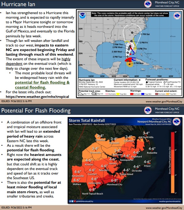
While this afternoon’s update once again included increased probabilities of moderate to major impacts, it will likely be tomorrow before we receive specific accumulation details.
Published: Thursday, January 29th, 2026 @ 1:49 pm
By: ENC NOW
|
 |
Government and its bureaucracy are not perfect, and never has been in this self-governed society, here at the local level, at our state level, and at our federal level, therefore, it is incumbent upon all elected politicians to seek a comfortable level of representation for our constituents.
Published: Tuesday, January 27th, 2026 @ 12:24 pm
By: Stan Deatherage
|
 |
What is the opposition to being tough on drugs and crime?
|
 |
A clear disregard for rules exists within senior party leadership.
|
 |
November 10, 2025 City Council Agenda
Published: Friday, November 7th, 2025 @ 3:34 pm
By: ENC NOW
|


