Press Release:
Good Morning Everyone,
This morning's update included minor adjustments to snow accumulations, with Beaufort County forecasted to receive between 8 and 12 inches. However, regardless of these or future adjustments to snowfall totals, we are still expected to receive
"Major Impacts" (Dangerous driving conditions, closures, disruptions with normal daily activities, etc.) from this weekend's winter weather.
Expected Hazards to Prepare For
We encourage everyone to ensure that your family, friends, and neighbors take time today to be prepared for the following possible outcomes.
Dangerous Road Conditions
Hazard
- Snow may begin accumulating on our roadways as early as noon on Saturday. These conditions will quickly deteriorate as we move through the evening hour, with roadways likely remaining dangerous through Wednesday, as temperature struggle to get above freezing.
Mitigation / Preparations
- Please be prepared to shelter in place and avoid unnecessary travel between noon Saturday and noon Tuesday. Doing so will prevent unnecessary vehicle accidents that require the response by our county's first responders and allow DOT crews time to plow our roadways.
- If travel is necessary, please drive with caution, and avoid elevated bridges like our Hwy 17 bypass if possible.
Cold Outside Temperatures
Hazard
- We will experience below freezing temperatures between 6pm today and noon Monday.
Mitigation / Preparations
- Please ensure that outside pets and animals have adequate shelter to protect them from these cold temperatures and falling precipitation.
- Avoid being outside if possible and utilize warm layers of clothing to cover exposed skin if you must be outside for extended periods of time.
Isolate Power Outages
- Hazard
- While widespread, long duration power outages are not expected, isolated outages from high winds, vehicle accidents, etc. are possible.
- Mitigation / Preparations
- Ensure that you have a way to stay warm in the event you lose power for several hours. Also make sure you have flashlights, charged electronic devices, etc.
Most importantly.....BE A GOOD NEIGHBOR
- Weather events like this quickly exceeds the abilities of public safety resources and requires a "whole community" approach. BE A GOOD NEIGHBOR by:
- Checking on elderly / vulnerable neighbors and family members. Especially if your community were to experience an isolated power outage. Ensure they are prepared to shelter in place from Saturday through Tuesday. (Warm clothes, blankets, food, medicine, flashlights, charged cell phone, etc.)
- Please avoid unnecessary travel between Saturday and Tuesday, and encourage your family, friends and neighbors to do the same.
Changes to our previous briefings have been
underlined below.
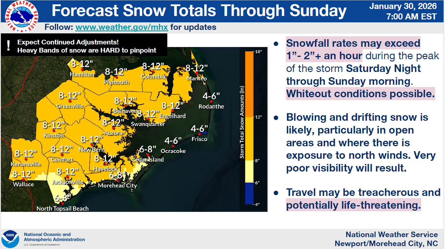
Snowfall Accumulations
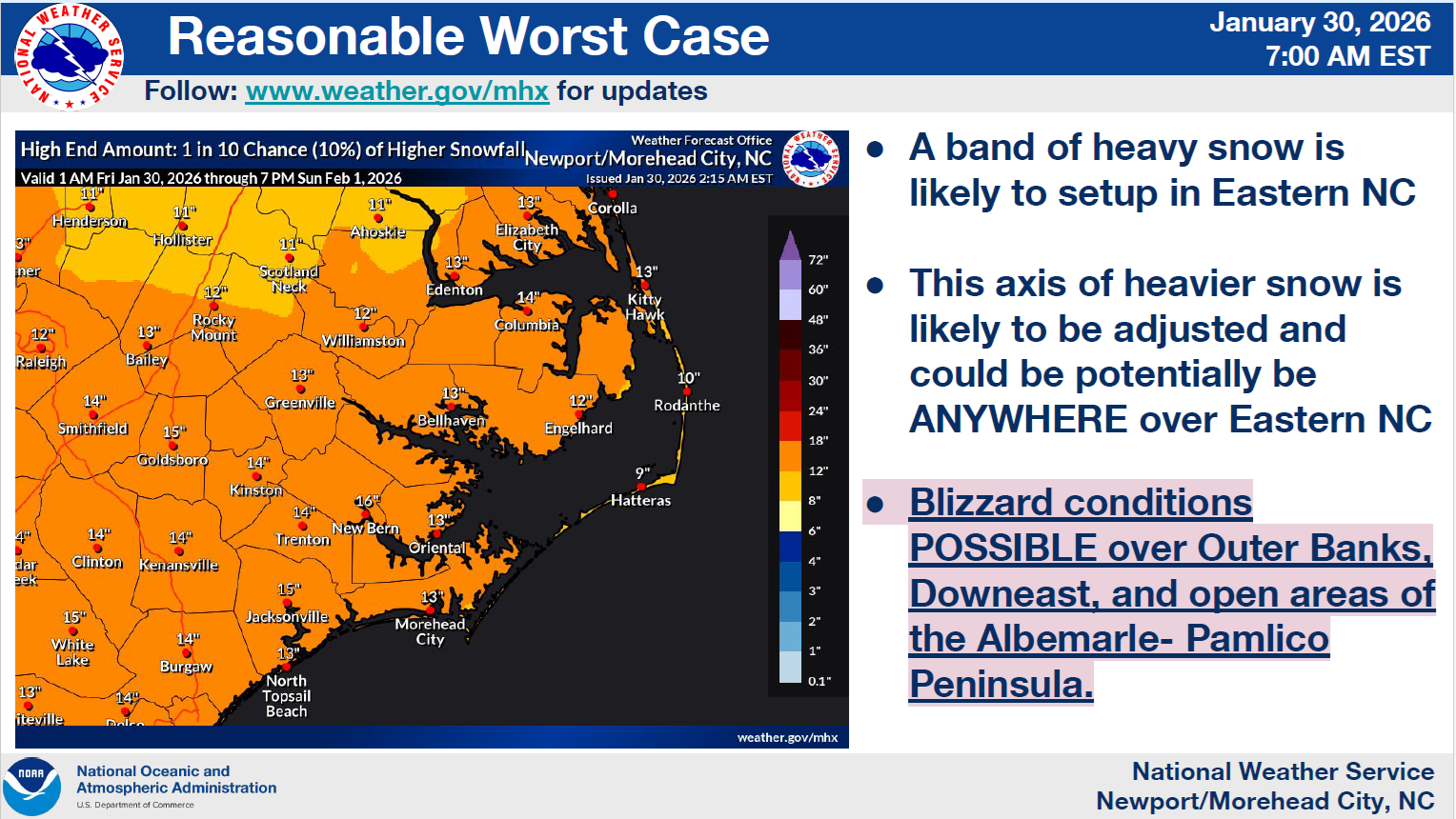
Our area is currently forecasted to receive an average of 8 to 12 inches of snow. However, a band of heavier snow is expected to set up somewhere along Eastern NC, producing locally higher amounts. Unfortunately, we will likely not know where that heavier band will be until it appears on radar. (See the "Reasonable Worse Case" graphic below for possible accumulation totals for areas that are impacted by this developing heavier bands of snow.)
Snowfall Accumulation Graphic
 Reasonable Worse Case Accumulation Graphic
 Timing of Impacts
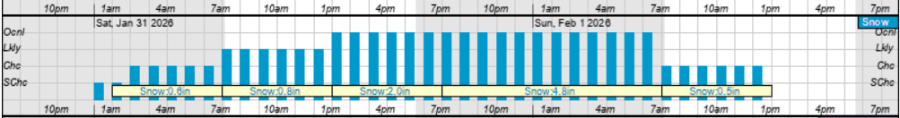
Snow
Light snow is currently forecasted to begin around 2am Saturday and continue through noon Sunday.
- Accumulating snow is likely by noon Saturday.
- Our heaviest snow is currently forecasted to occur between 7pm Saturday and 7am Sunday morning.
Hourly Snowfall Graphic for Saturday & Sunday
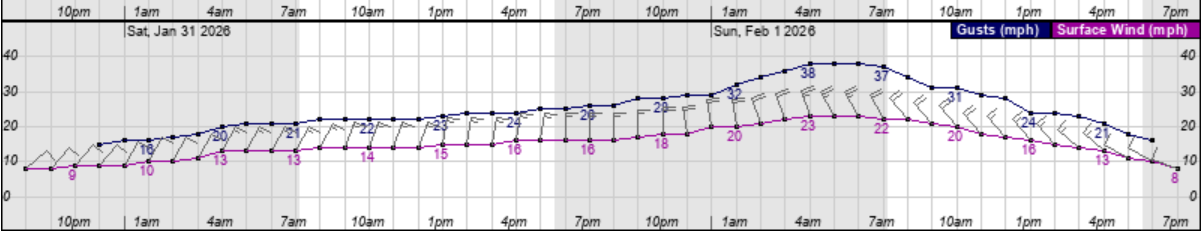
 High Winds
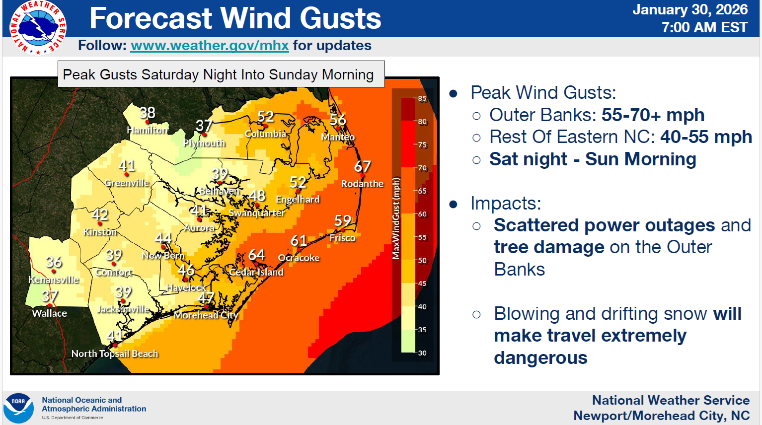
North and Northwest winds will begin to increase shortly after sunrise Saturday, becoming sustained between 15 and 25 mph, with frequent gusts of 25 to 40 expected through sunset Sunday.
- Our highest winds are expected between 1am and 10am Sunday.
- Blizzard like or "whiteout" conditions are possible Saturday and Sunday and fall snow will be accompanied by high winds.
Hourly Wind Graphic for Saturday & Sunday
 Peak Wind Gust Graphic for Saturday Night - Sunday Morning
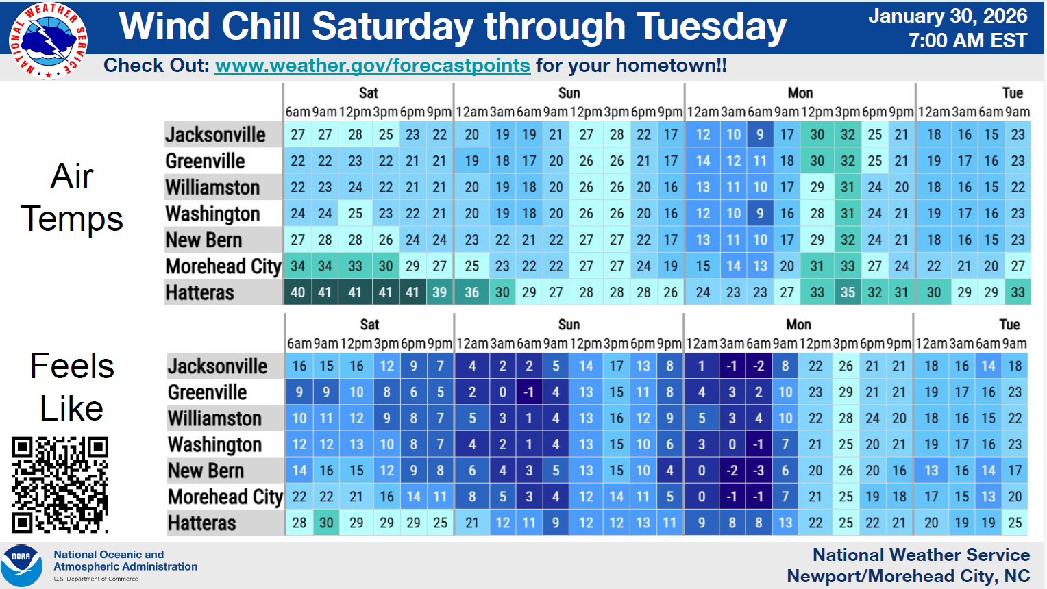
 Temperatures & Windchills
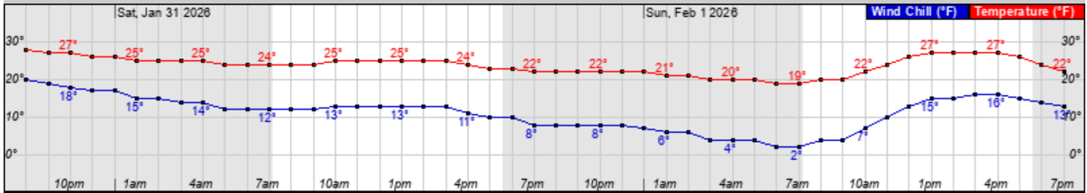
Temperatures are expected to drop below freezing around sunset Friday and remain below freezing through noon on Monday, with windchills between 10 and 15 degrees Saturday night and 2 to 10 degrees Sunday night.
Hourly Temperature & Windchill Graphic for Saturday & Sunday
Please see the email below and the attached briefing from the National Weather Service (NWS) for additional information. A video of their 9am forecast briefing can be viewed using the following
link.
We anticipate releasing our next update by
5pm this afternoon.
As always, thank you all for what you do to keep Beaufort County informed, prepared and safe.
Chris Newkirk
Deputy Director
Beaufort County Emergency Services
1420 Highland Dr
Washington, NC 27889
Office: (252)940-6511
Cell: (252) 378-5352
Good morning and Happy Friday,
Attached is the latest briefing for the winter storm expected to impact the area this weekend.
- Winter Storm Watches have been upgraded to Winter Storm Warnings for all of eastern NC with the potential for significant accumulating snow.
- High Wind Watches have been have been upgraded to High Wind Warnings for areas along the coast from the Northern Outer Banks south all the way through Eastern Carteret.
- Wind Advisories have been issued for mainland areas adjacent to the Albemarle and Pamlico Sounds and the Neuse River.
- Coastal Flood Watches for the Northern Outer Banks and Hatteras and Ocracoke Islands have been upgraded to Coastal Flood Warnings.
- Coastal Flood Watch for Eastern Carteret County remains in effect.
- Extreme Cold Watch remains in effect for all of Mainland eastern North Carolina and the Northern Outer Banks for wind chill values at or below zero for Sunday and Monday mornings.
- High Surf Advisories have been issued for areas along the coast from the Northern Outer Banks south all the way through Eastern Carteret.
- Storm and Gale Watches have been upgraded to Storm and Gale Warnings for area waters, with very dangerous marine conditions expected.
NWS_Morehead_City_Briefing_8_Weekend_Winter_Storm.pdf
Regards,
NWS Newport/Morehead City
NOAA - National Weather Service
Newport/Morehead City, NC Weather Forecast Office
533 Roberts Rd
Newport, NC 28570


