Press Release:
Good Afternoon Everyone,
Like many of you, our office is monitoring the evolving forecast for both Tropical Storm Humberto and Invest 94L. The proximity of these two storms in the Atlantic and the timing of an approaching front from the central US has created uncertainty and numerous changes in the forecasted tracks of these system. For example, forecast runs throughout the weekend indicated that both Humberto and 94L would remain offshore. However, Sunday night's update began to show a westward shift, with today's updates suggesting that 94L will make landfall along the South Carolina coast late Monday afternoon / Tuesday morning. Below is a summary of the current forecast information and what we should all continue to look for over the coming days.
T
ropical Storm Humberto
Humberto is expected to strengthen to Hurricane status but remain offshore with no threats to Beaufort County.
Invest 94L
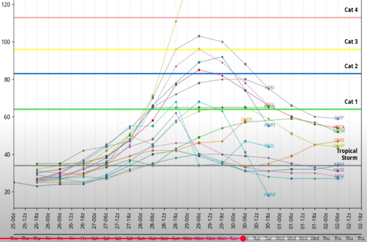
This is the system that we need to watch closely. 94L is expected to develop into Tropical Storm Imelda late tomorrow afternoon / Saturday morning. Most of the forecast models vary in wind speed intensities ranging from a strong tropical storm to a low Category 2 by Monday as seen in the graph below.
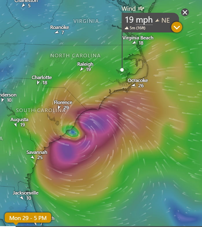
The latest EURO update suggests landfall near Mrytle Beach around 2am Tuesday morning as seen in the graphic below. (NOTE: This is a northern shift, as the 11am run of this same model indicated landfall near Charleston)
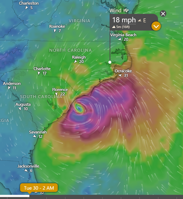
The GFS has the storm moving slightly faster and further south, with landfall forecasted to occur near Charleston as seen below. (Note: This model has continued to indicate landfall near Charleston throughout the day.)
Please see the email below and attached briefing from the National Weather Service (NWS) for more information
What should we be watching for?
As mentioned, there are a lot of complex steering variables at play with these approaching systems, so we will need to monitor them closely over the coming days. In doing so, we encourage everyone to monitor TRUSTED sources for updates and information.
We would not be surprised to see the forecasted track continue to shift as we move into our weekend. With that being said, Saturday will likely be an important day for all of us, as we hope to see some degree of confidence in the forecast. (Note: As a coastal community, we recognize that many of you are concerned with the potential for storm surge. We do not expect to see storm surge forecasts before Saturday, as these are seldom released more than 72 hrs from landfall.) Until then, please use this time to review your hurricane plans.
- Is your home, storage buildings, and outside furnishings / belongings prepared for the common threats of a tropical storm or hurricane?
- Are you prepared for power or other infrastructure outages?
- Are you prepared to be self sufficient and shelter in place for up to 5 days if necessary? (Food, water, medicines, hygiene items, etc.)
- Do you have a self-reliant plan to evacuate if needed? Where would you go? (Stay with family, friends, a motel, etc.)
- Do you have a self-reliant plan to keep your pets and / or livestock safe?
- How will you communicate with family and / or friends?
Now is the time to plan and prepare, not panic.
As always, we will continue to share updates as we receive them, and we thank you all for what you do to keep Beaufort County informed, prepared and safe.
Chris Newkirk
Deputy Director
Beaufort County Emergency Services
1420 Highland Dr
Washington, NC 27889
Office: (252)940-6511
Cell: (252) 378-5352
Good evening partners,
Tropical Storm Humberto formed earlier this evening in the Atlantic basin. AL94 has not yet developed into a defined system but is forecast to sometime this weekend near the Bahamas.
Key Messages
- The risk of impacts from AL94 are increasing for portions of the Southeast U.S.
- Confidence in coastal impacts from long-period swell associated with Humberto is increasing for ENC
- Inland impacts associated with AL94 are possible, but are heavily dependent on the track and intensity
- This continues to be a unique setup with impacts from two separate tropical systems
- Here is our Latest Briefing. The next briefing is scheduled by 6:00 pm EDT on Friday, September 26, 2025 (or earlier if conditions warrant)
Social media accounts may show dramatic model forecasts during this event. Please follow official sources for weather information (like our briefings and the National Hurricane Center) and Beware the Share.
We will provide future updates as confidence increases. If you have any questions or concerns, please don't hesitate to reach out to us.
NWS_Morehead_City_Tropical_Briefing_2.pdf
Regards,
NWS Newport/Morehead City
NOAA - National Weather Service
Newport/Morehead City, NC Weather Forecast Office
533 Roberts Rd
Newport, NC 28570


