Press Release:
Good Evening Everyone,
Like many of you, our office has been monitoring the potential for impactful winter weather this weekend. Current forecast details for Beaufort County include:
Temperatures
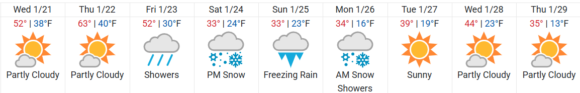
While we are expected to experience seasonal temperatures through Friday afternoon, our daytime highs are expected to be at or near freezing Saturday, Sunday and Monday, with windchills below 30 and nighttime lows in the upper teens to low 20s.
10-day Forecast Graphic
 Precipitation (Snow / Sleet / Freezing Rain)
Friday
Precipitation (Snow / Sleet / Freezing Rain)
Friday
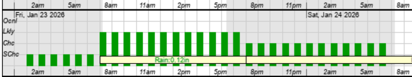
- Light rain, in the form of scattered showers, is expected to move through our area after sunrise on Friday and continue through the daytime hours.
Friday Rain Graphic
 Saturday
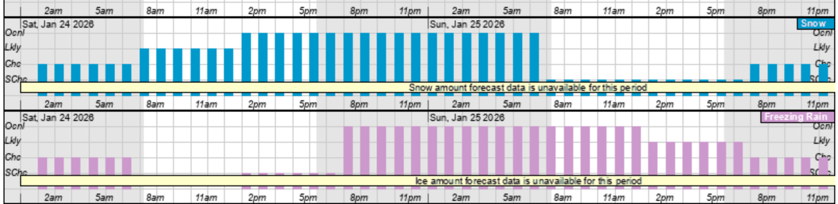
- Heavier precipitation is expected throughout the day on Saturday, as our temperatures remain near or below freezing. This combination is currently forecasted to produce a mixture of snow and freezing rain for most of the afternoon and evening hours. However, it appears that our heaviest precipitation will occur between 1p Saturday and 6am Sunday morning.
Saturday Snow (blue) and Freezing Rain (pink) Graphic
 Sunday
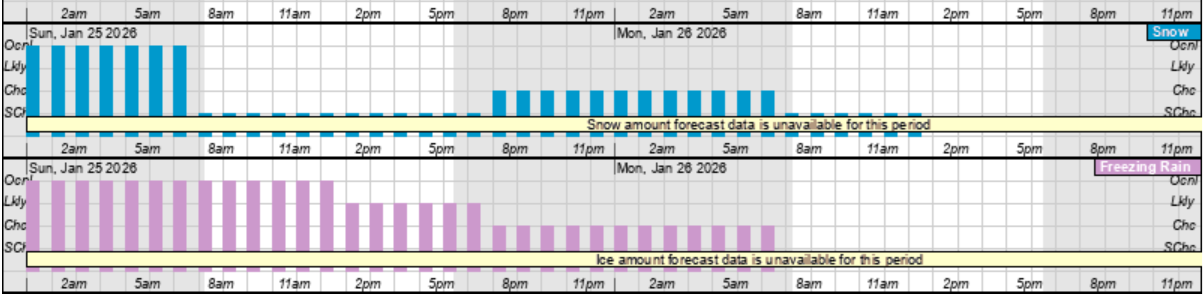
- While precipitation is currently forecasted to be lighter on Sunday, a mixture of snow and freezing rain is currently forecasted to continue through sunrise Monday morning.
Sunday Snow (blue) and Freezing Rain (pink) Graphic
 Accumulations
While there is a lot of potential for winter weather impacts this weekend, it is simply to early for certainty in forecasted totals for snow, freezing rain, or any combination of the two. While forecast models continue to suggest that portions of the mid Atlantic could receive historical snow and ice accumulations, Beaufort Count is frequently seen to be on the border line of snow and freezing rain, and this temperature & precipitation line will likely continue to shift slightly north or south with forecast runs over the next 48 hrs.
What to Look for and Prepare for.
While details related to possible accumulations of snow and ice are uncertain, we encourage everyone to ensure that your families, friends and neighbors take time over the next few days to monitor this evolving forecast and consider what actions you would need to take to be prepared for the following possible outcomes.
- Impactful Snow & Ice Accumulations
- Do you have enough food, supplies and medicine to last several days (Saturday through Wednesday) in the event you are unable to travel due to hazardous road conditions?
- Are you prepared for power outages that last longer than 24 hrs? (How would you stay warm? How would you cook? Do you have battery operated lighting and a way to charge electronic devices?)
- Are your outside pets and livestock protected from hazardous winter weather conditions? (Do they have adequate shelter? Do they have access to water that is not frozen?)
We anticipate having more forecast details late Wednesday or early Thursday.
As always, thank you all for what you do to keep Beaufort County informed, prepared and safe.
Chris Newkirk
Director
Beaufort County Emergency Services
121 W 3rd St.
Washington, NC 27889
Office: (252)946-0079
Cell: (252) 378-5352


