News Release:
Good Afternoon Everyone,
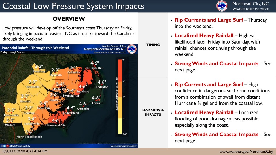
Our office is currently monitoring the forecasted development of a coastal low pressure system that is expected to bring rain and elevated winds to our area this weekend. The current forecast for Beaufort County is outlined below.
Rain
- Rain will begin to move into the area around 8am Friday morning and continue through 1pm Saturday. 2 to 3 inches of rain is expected for areas west of Bath and Blounts Creek during this time, with areas west receiving 3 to 4 inches.
- Our heaviest rains are expected to occur between 2pm Friday and 8am Saturday morning.
Winds
- North and Northeast winds will begin to increase around sunrise Friday morning becoming sustained between 10 and 15 mph with frequent gust of 25 to 30 mph possible through 1pm Saturday.
- Winds will begin to transition to the Northwest after 1pm Saturday and remain sustain between 10 and 15 with frequent gust of 20 to 25 mph through sunrise Sunday.
Please see the email below and attached briefing from the National Weather Service for additional information. We will continue to pass along these updates as we receive them.
As always, thank you all for what you do to keep Beaufort County informed, prepared, and safe.
Chris Newkirk
Director, Beaufort County Emergency Services
121 W 3rd St.
Washington, NC 27889
Office:
(252) 946-0079 • Cell:
(252) 378-5352
National Weather Service Email
Good Afternoon,
Impacts to eastern North Carolina are likely as low pressure develops off the Southeast coast over the next couple of days and tracks toward the Carolinas through the weekend. While the probability that this low will become tropical has increased a little to 40% (as of 2 PM), we want to emphasize that impacts are not directly related to whether or not this system gets named. Localized heavy rainfall is likely, especially along the coast, beginning Friday. However, the threat for strong winds and coastal impacts is very dependent on the track and strength of the low, and is very uncertain that this time. Please see the attached briefing for our latest thinking.
Please let us know if you have any questions.
Regards,
NWS Newport/Morehead City
NOAA - National Weather Service
Newport/Morehead City, NC Weather Forecast Office
533 Roberts Rd
Newport, NC 28570


