The most recent tropical storm, Beryl, which washed ashore near the Georgia / Florida state line, May 27, 2012, the remnants of which have moved into the center of the Southeastern United States, now threatens torrential rainfall for all of eastern North Carolina. This prospective torrential rainfall comes at a time when the soil in most of Beaufort County is already rather saturated.
Additional rainfall, in excess of 3 inches, could well contribute to a pattern of flooding in low lying areas - especially basements - like mine which is on decidedly high ground. I will prepare my pump for the worst. I advise you do the same, should you be burdened in this same situation.
Further cautionary advice should be heeded from Beaufort County's Emergency Services Coordinator John Pack.
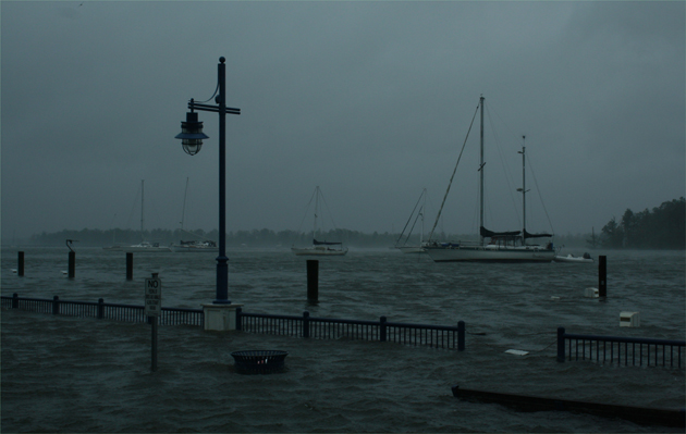 Rain events, and hurricanes, like during Hurricane Irene shown here in Washington, NC, along the waterfront, make water a natural substance to be feared: Above photo by Stan Deatherage
Press release from Beaufort County's Emergency Services Coordinator John Pack
Rain events, and hurricanes, like during Hurricane Irene shown here in Washington, NC, along the waterfront, make water a natural substance to be feared: Above photo by Stan Deatherage
Press release from Beaufort County's Emergency Services Coordinator John Pack
Good Morning:
I wish I could tell you Beryl was not going to impact us, however, that would be misleading. The National Weather Service has already issued a Flood Watch for Beaufort County beginning late tonight and all day tomorrow. If the remains of Beryl track as expected with the heavy rain we should expect some flash flooding late tonight into early Wednesday. This could result in prolonged flooding in low lying areas and cause flooding in other areas of the County not normally victims of this type of flooding.
We must use caution traveling to the office tomorrow morning and avoid if possible travel after arriving at work until Beryl's flooding impact is fully realized. Our staffs should follow a very simple rule: "Stay alive! Don't drive through standing water". I believe there will be areas of the county that will have a Flash Flood Warning and/or possibly a Flood Warning for specific geographic locations. Please listen to NOAA weather radio and local updates as they become available.
We can expect some wind in the area of 25mph with gust as high as 40mph. Depending on the rain it is possible trees could come down across power lines and cause power outages. Offices should use caution if there technology is power dependant as phasing issues and flickering of our power providers is possible.
If an office structure suffers from roof leaking then special caution should be taken by staff to lessen those impacts prior to leaving work today.
I do not envision a full opening of the EOC, however, a limited staff may be necessary to monitor and report flooding. First response vehicles must use great caution while responding to calls for assistance during the heavy rain. First responders should use great caution when providing traffic control at accidents or high water events as visibility could be greatly reduced during the periods of heavy rain.
We will keep you updated as we receive updated forecast or important traffic related incidents.
John Pack
Coordinator
Beaufort County Emergency Services


