News Release:
Good Morning Everyone,
Our office is currently monitoring an approaching weather system that will bring high winds, cold temperatures, periods of heavy rain and the potential for severe storms with isolated tornados to our area on Saturday. The current forecast details for Beaufort County are as follows:
Winds
- South winds will begin to increase after sunrise Saturday transitioning to the NW after 1pm. Sustained winds between 15 and 25 mph, with frequent gust between 35 and 45 mph are expected between 10am Saturday and 10am Sunday. Occasional gust greater the 45 mph is also possible during this time, especially for the Pamlico Beach and Aurora communities.
- A Gale Warning has been issued for all of our county's shoreline, meaning winds between 34 and 47 knots are expected. (39mph - 54mph)
- These sustained winds are expected to create low water levels along the Pamlico River Saturday and Sunday.
Temperatures
- Temperatures are expected to drop significantly during the day Saturday, from 65 degree at sunrise to 33 degrees near sunset. These temps, accompanied with high sustained winds will result in windchills in the teens overnight Saturday and for most of the day on Sunday.
Precipitation
- Rain chances will begin to increase after 7pm tonight, and continue through 7pm Saturday, with most areas receiving between 1 and 2 inches of rain. Periods of heavy rain, capable of producing localized flash flooding will be possible during this time, as this moisture moves through the area in bands / cells.
- A mix of rain and snow is possible around sunset Saturday, as temperatures will be at or below freezing as precipitation exits our area. However, no accumulation is expected.
Severe Storms / Isolated Tornados
- Severe storms are possible between 10pm tonight and 10am Saturday, with the greatest threat occurring between 4am and 10am Saturday morning, especially for areas south and east of Blounts Creek, Bayview and Sidney.
Please see the email below and attached briefing from the National Weather Service for additional information.
We encourage everyone to take time today to secure any loose outside items susceptible to high winds, protect exposed plumbing from freezing temperatures and ensure outside pets and livestock have adequate shelter for these forecasted conditions. We also ask that you ensure you, your family, friends and neighbors have a way of being notified of watches and warnings during the overnight hours, as the threat of severe weather will occur while most people are sleeping. (Weather Radio, Weather Alert Apps, etc.)
Our next update is scheduled for 5pm today. Please continue to monitor local media outlets for more frequent updates.
As always, thank you all for what you do to keep Beaufort County informed, prepared and safe.
Chris Newkirk
Deputy Director, Beaufort County Emergency Services
1420 Highland Dr
Washington, NC 27889
Good Morning,
Attached you'll find our first full briefing for strong cold front that will affect our area tomorrow (Saturday 3/12).
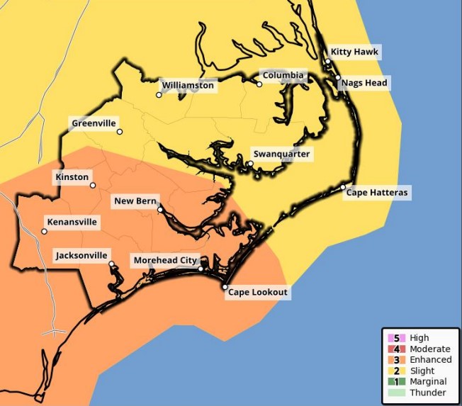
No big changes since yesterday, however we have higher confidence in expected impacts to the area. The biggest threat remains severe weather both ahead of and along the cold front from early Saturday morning through Saturday afternoon. Very strong winds will also accompany this front, as well as minor coastal flooding and ocean overwash across the Outer Banks.
If you have any questions or concerns, please call the office at (252) 223-5737 Ext. 6.
Regards,
Shane
NWS Morehead City


