Good Morning Everyone,
Our office, along with the National Weather Service (NWS) is monitoring an approaching weather system that is forecasted to bring windy conditions, widespread showers and possible thunderstorms to our area over the weekend.
Current forecast details for Beaufort Co.
Winds
- NE winds will begin to increase Thursday morning, becoming sustained between 10 and 15 mph with frequent gust up to 20 mph. Winds will increase again on Friday, becoming sustained between 15 and 20 mph with gust between 25 and 30 mph possible through midnight Saturday.
- Our highest winds are expected to occur between 10am and 7pm Saturday.
Rain
- Rain will begin to move into the area around 8pm Friday, and continue through Monday. Areas along and west of Hwy 17 are currently forecasted to receive 1 1 /2 to 2 inches during this time, with areas west receiving 2 to 3 inches.
- Our heaviest rains are expected to occur between 2pm and 8pm Saturday, between 8am and 8pm Sunday and between 2pm and 6pm Monday.
Thunderstorms
- Thunderstorms are possible with this event, and are most likely to occur between 2pm and 7pm Saturday.
Please see the email below and attached briefing from the National Weather Service for more information. Their next briefing is scheduled for 8am tomorrow morning. We will continue to pass along information as we receive it.
As always, thank you all for what you do to keep Beaufort County informed, prepared and safe.
Chris Newkirk
Deputy Director
Beaufort County Emergency Services
1420 Highland Dr
Washington, NC 27889
Office: (252)940-6511
Cell: (252) 378-5352
Hello,
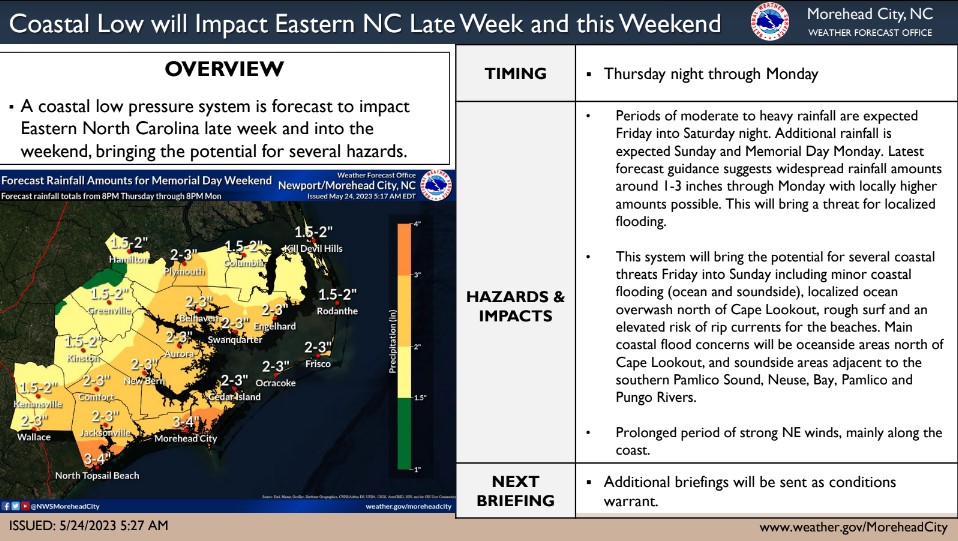
A slow moving, developing low pressure system offshore, is forecast to come ashore into South Carolina Saturday or Sunday. This low will bring widespread showers/possible thunderstorms and strong northeasterly winds to eastern NC beginning Thursday night and continuing into the Memorial Day weekend.
Some impacts expected form this system include:
Rainfall of 1-3" with locally heavier amounts possible through Memorial Day (Monday).
Gale Force Winds with seas building to 10-15 ft Friday night into Saturday.
The strong winds will also result in rough surf, minor coastal flooding (ocean and sound side), localized ocean over wash north of Cape Lookout, and an elevated rip current risk for the beaches.
The main coastal flood concerns will be oceanside north of Cape Lookout, and sound side adjacent to the southern Pamlico Sound, Neuse, Bay, Pamlico, and Pungo Rivers.
Another briefing will be issued by 8 AM Thursday morning. If you have any questions please don't hesitate to contact us.
Regards,
NWS Newport/Morehead City
NOAA - National Weather Service
Newport/Morehead City, NC Weather Forecast Office
533 Roberts Rd
Newport, NC 28570


