Pitt Center Offers Nontraditional Summer Hours | Eastern NC Now
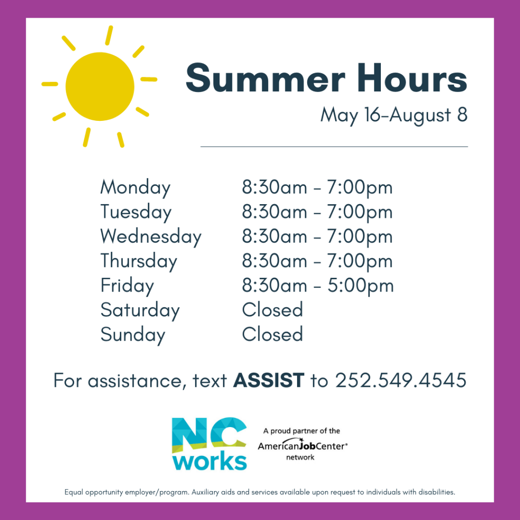
The Pitt County NCWorks Career Center, located at 3101 Bismarck Street in Greenville, will be offering nontraditional hours for summer beginning May 16.

 |
Our office continues to monitor the potential for severe storms and periods of heavy rain between Wednesday and Saturday. Today’s forecast updates shifted some of the early precipitation north and west of our area, which resulted in minor changes to the timing of our expected rainfall
Published: Thursday, July 23rd, 2026 @ 9:40 am
By: ENC NOW
|
 |
Our office is monitoring the potential for severe storms and periods of heavy rain between Wednesday and Saturday. Please see below for Beaufort County's forecast details.
Published: Wednesday, July 22nd, 2026 @ 7:52 pm
By: ENC NOW
|
 |
Memorial Day is a time when we as a nation pause to remember and honor the sacrifice of the men and women who gave their lives in the service of our nation.
Published: Sunday, May 24th, 2026 @ 9:47 am
By: Dave Hudson
|
 |
In 1920, the American Legion adopted the red poppy as the symbol of remembrance of those who gave their lives in war.
Published: Sunday, May 24th, 2026 @ 9:46 am
By: Diane Rufino
|
 |
The great misnomer for non Christians that the day Jesus Christ was executed by occupying Romans, celebrated by Christians as "Good" Friday, must be a paradox of ominous proportions.
Published: Monday, April 6th, 2026 @ 4:22 am
By: Stan Deatherage
|
 |
A North Carolina State Senate race is heading for a recount after the two pro-Trump Republicans come down to a two vote margin.
Published: Sunday, April 5th, 2026 @ 6:43 pm
By: Daily Wire
|
 |
This is simply a failure of will, and we are here to help impose that will today, so that to me is the simple punchline," said State Treasurer Brad Briner. "I appreciate the leaders of Rocky Mount being here, but we need to get to a place where there is the will to fix a very, very serious problem.”
Published: Saturday, April 4th, 2026 @ 8:24 pm
By: Carolina Journal
|
 |
Our office is monitoring the likelihood of severe weather across Eastern NC for tomorrow. Forecast details for Beaufort County include:
Published: Monday, March 16th, 2026 @ 12:20 pm
By: ENC NOW
|
 |
This morning’s update included minor adjustments to snow accumulations, with Beaufort County forecasted to receive between 8 and 12 inches.
Published: Sunday, February 1st, 2026 @ 8:40 pm
By: ENC NOW
|

 |
This afternoon’s update continues to indicate “Major Impacts” (Dangerous driving conditions, closures, disruptions with normal daily activities, etc.) from this weekend’s winter weather with Beaufort County currently forecasted to receive 10 and 14 inches of snow.
Published: Friday, January 30th, 2026 @ 10:17 am
By: ENC NOW
|
 |
While this afternoon’s update once again included increased probabilities of moderate to major impacts, it will likely be tomorrow before we receive specific accumulation details.
Published: Thursday, January 29th, 2026 @ 1:49 pm
By: ENC NOW
|
 |
Our probability for experiencing “Moderate Impacts” (hazardous driving conditions, closures, disruptions with normal daily activities, etc.) increased to between 60 and 80% with this morning’s update
Published: Wednesday, January 28th, 2026 @ 9:21 pm
By: ENC NOW
|
 |
Our office continues to monitor the forecasted potential of another round of winter weather for this Saturday and Sunday.
Published: Wednesday, January 28th, 2026 @ 9:53 am
By: ENC NOW
|
 |
This afternoon’s update continues to shift winter weather impacts further west and north, with Beaufort County now forecasted to receive less than 1/8 of an inch of accumulating ice from freezing rain, and little to no measurable snow.
Published: Sunday, January 25th, 2026 @ 4:34 pm
By: ENC NOW
|
 |
Today's weather updates have suggested slightly warmer temperatures for our area than was previously forecasted, which is shifting significant snow and freezing rain accumulations further west and north.
Published: Sunday, January 25th, 2026 @ 4:18 pm
By: ENC NOW
|
 |
Like many of you, our office has been monitoring the potential for impactful winter weather this weekend. Current forecast details for Beaufort County include:
Published: Sunday, January 25th, 2026 @ 1:34 pm
By: Announcements
|
 |
A federal judge will not issue an injunction blocking local Watauga County election districts created by the Republican-led North Carolina General Assembly.
Published: Tuesday, January 20th, 2026 @ 2:10 pm
By: Carolina Journal
|
 |
The FBI has captured Alejandro “Alex” Rosales Castillo, who is on the 10 Most Wanted Fugitive list and wanted in connection with a 2016 murder in Charlotte.
Published: Tuesday, January 20th, 2026 @ 1:59 pm
By: Carolina Journal
|

 |
A major redevelopment project planned in Morehead City has been scrapped following strong public opposition over the use of eminent domain.
Published: Monday, January 19th, 2026 @ 7:16 pm
By: Carolina Journal
|
 |
The Christmas Story is told best through the voice of the Apostle Luke. Hallelujah, The Christ Child is born!
Published: Friday, December 26th, 2025 @ 1:48 pm
By: Stan Deatherage
|
 |
I found these (Piano) guys, when I was searching for Christmas Carols, specifically "Carol of the Bells".
Published: Friday, December 26th, 2025 @ 11:02 am
By: Stan Deatherage
|
 |
Sarah McLachlan has always been a guilty pleasure of mine. As an impassioned "rocker," with somewhat of a sentimental streak, I have always dug talented balladeers, especially the females.
Published: Wednesday, December 24th, 2025 @ 7:55 pm
By: Stan Deatherage
|
 |
As we approach the Yuletide season, we are requesting that our readers send us Christmas greetings, through song, story, or verse that is important to you.
Published: Friday, December 12th, 2025 @ 7:52 am
By: Stan Deatherage
|
 |
This rendition of "Fairytale of New York" rivals the original, and once again puts Walk Off the Earth as one of the great cover bands of all time.
Published: Thursday, December 11th, 2025 @ 10:27 am
By: Stan Deatherage
|
 |
There were no major changes in the forecast for our area with this morning’s update. While much of Beaufort Co. could see a mix of rain and snow later today, impactful accumulations will remain to our north and west.
Published: Tuesday, December 9th, 2025 @ 9:34 am
By: ENC NOW
|
 |
Fortunately, the haters can't stop Melania Trump from ringing in the Christmas season.
Published: Tuesday, December 9th, 2025 @ 12:20 am
By: Daily Wire
|
 |
We are currently monitoring a forecast for cold rain with a late mix of snow for tomorrow afternoon.
Published: Monday, December 8th, 2025 @ 4:26 pm
By: ENC NOW
|


